Tonight we are parked at the Kewadin Casino in Christmas, Michigan (map), just northwest of Munising. While there is a perfectly nice forest service campground right across the street, we actually drove into Munising today, five miles further along MI-28, and spent the evening on a scenic cruise past the Pictured Rocks. By the time we returned to the harbor, we just needed a close-in place to spend the night, as there was not much daylight left. The casino offers RV parking for free, and that includes, believe it or not, 50-amp electric service.
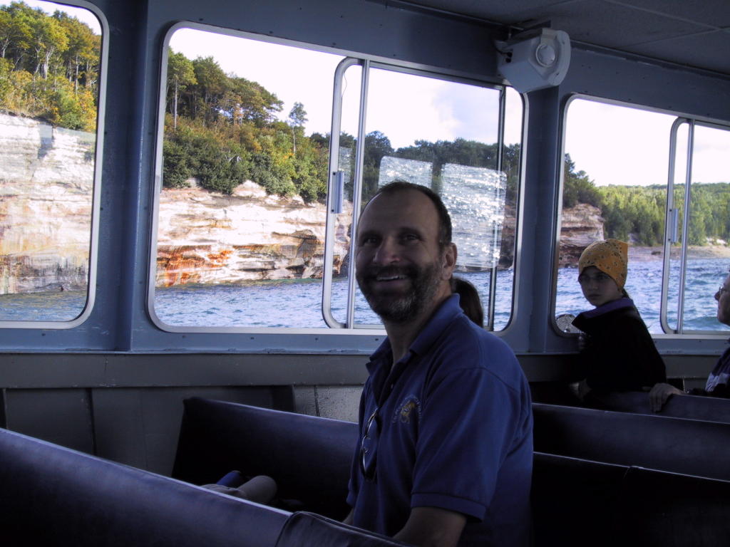
The Pictured Rocks cruise was quite spectacular, and we are glad we did it. We arrived in time to do some grocery shopping and make the 5pm departure. We are only a few dozen miles from where we started the day in Marquette, but we got a late start owing to a haircut appointment.
Today our thoughts are again with the victims of hurricane Katrina. Long-time readers of this blog will recall that we made a complete transit of the gulf coast, from the Florida panhandle all the way to South Padre Island, back in January. As we passed through Gulfport and Biloxi, I remarked that they had been spared major damage from Ivan. Regrettably, both those cities are now destroyed, along with, I am sure, the nice state park where we stayed west of Bay St. Louis. The commercial park where we stayed in New Orleans is now under water, and it looks like the elevated section of I-10 nearby is in ruins.
We are thankful to have had a chance to visit those areas last year -- they will be very different from today forward. Also, we are able to put some of the images we are seeing on the news into a more human perspective -- the extent of the catastrophe seems, to us, far worse than it appears from the media coverage.
We sent our donation today to the American Red Cross. While I do not want to make a habit of doing this here, I would like to appeal to our readers to do the same. Donations can be made online with a credit card by going to their web site.
Tuesday, August 30, 2005
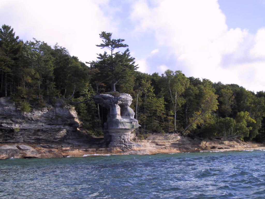
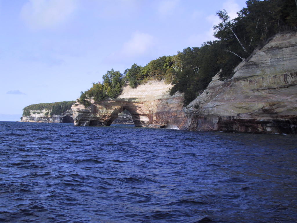
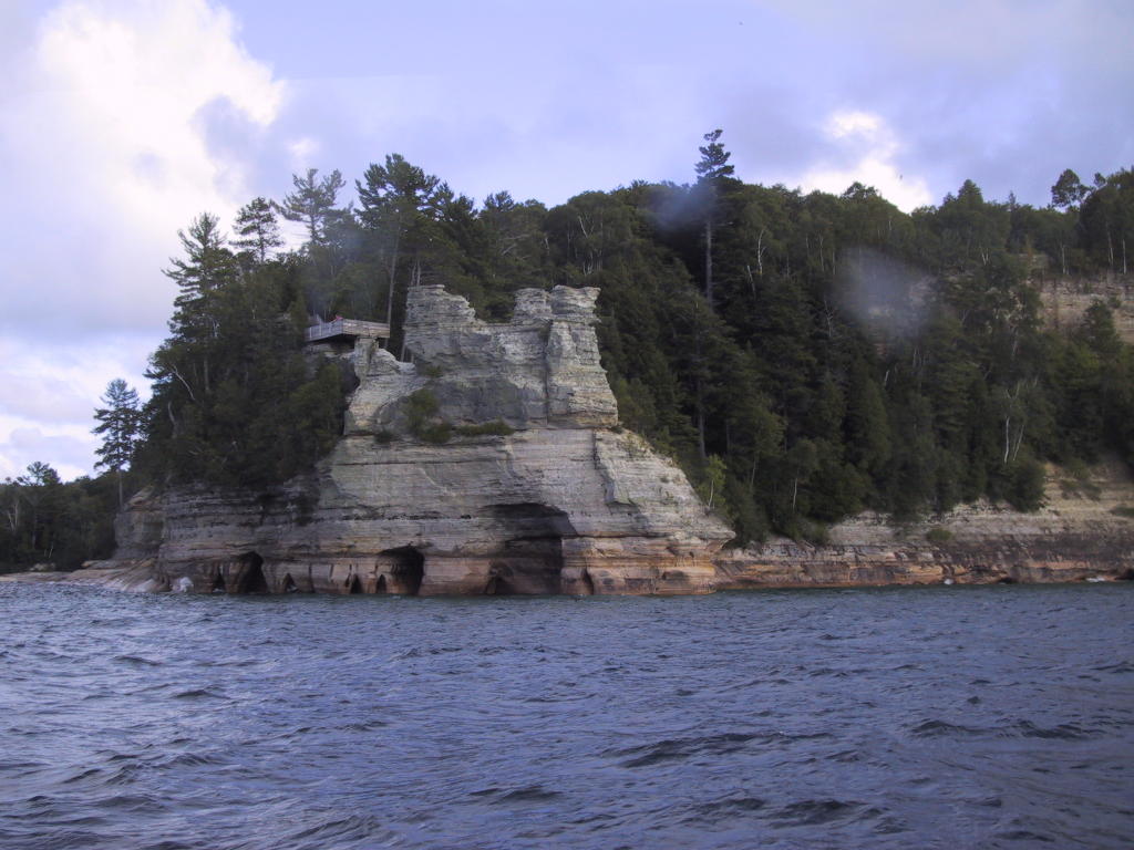
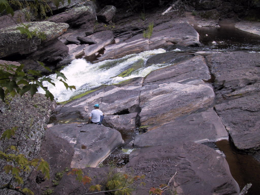
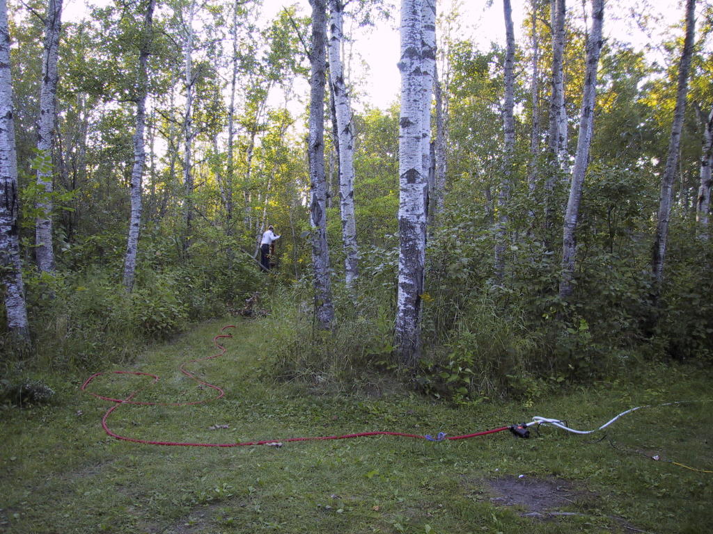
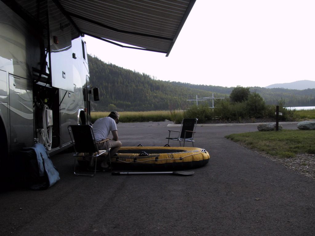
Our visit to Pictured Rocks National Lakeshore: According to our guidebooks, the best way to see the park is by boat, so we took a narrated 3-hour tour. The weather was gorgeous, with big puffy clouds, light wind, and clear, if a bit rough, water. This is Pulpit Rock; the tree roots are completely exposed, and reach over the abyss to the mainland.

Thinking about victims of Katrina
We are visiting friends in Marquette, on Michigan's upper peninsula. (No map today, in respect for their privacy.) Our friends are prominent members of the community here, and gave us the grand tour of the town last night, followed by dinner at the most excellent and historic Landmark Inn.
We spent most of yesterday morning, plus a few hours last night after our visit ended, glued to the TV watching storm coverage. We keep wondering if there is something we should or could be doing (other than cash contributions) to help. We have enlisted with the Red Cross as disaster operations volunteers, but our scheduled training is still a month away, and, by policy, there is nothing they can do with us until we have completed the training.
It is likely, of course, that the cleanup from Katrina (and ongoing sheltering of victims) will still be well underway when we complete our training in early October, but that seems like an eternity from now. In any case, we are trying to keep our post-training schedule open and our plans fluid.
From here, we will be heading east toward Sault Ste. Marie and the Mackinac Strait.
Monday, August 29, 2005

Sunday, August 28, 2005
Tip of the Keweenaw Peninsula
We had a pleasant two-night stay at Black River Harbor. Yesterday we mostly rested in camp, though we did do a moderately strenuous bike ride combined with a fair bit of hiking (actually, stair climbing) to visit several of the waterfalls along the Black River.
We also wandered down to the actual harbor, a small affair operated by the forest service and staffed by a concessionaire. I was amused to note that if Odyssey had been a boat, it would have cost us $20 to moor her overnight, so the $12 we paid in the campground was a relative bargain.
After returning this morning to US-2, we soon veered north again to the lake, and on to the Keweenaw peninsula. I say peninsula because that is what it is generally called, but completion in the 1860s of the Portage Lake Ship Canal actually made most of it into an island.
After crossing the Portage Canal Lift Bridge and traversing the western/northern shoreline of the peninsula on Lake Shore Drive, we landed here at Fort Wilkins State Park (map). We have a nice site overlooking Fanny Hooe Lake, which is just across the road from Copper Harbor on Lake Superior.
Fierce winds today along the big lake, and I couldn't get the lyrics to The Wreck of the Edmund Fitzgerald out of my head. Although a few August gusts hardly constitute the Witch of November...
Saturday, August 27, 2005
Black River Harbor, on Michigan's Upper Peninsula
Yesterday afternoon we traversed the part of Wisconsin that juts out into Lake Superior, after passing through Duluth in the morning. We were on WI-13, after departing US-2. I am sure this peninsula has a name, but I don't know what it is. We ended the day in the lakeside tourist town of Bayfield. We had planned to take the ferry over to Madeline Island, where we read about a nice state park campground, however the ferryman wanted $120 to take Odyssey on a round trip, and we deemed that a bit much for an overnight.
We opted instead to spend the night at the nice lakeside campground, not in any of our directories, run by the city of Bayfield (map). It was beautiful and quiet, though we had some heart-stopping moments bringing Odyssey down the steep park road and under the low trees. The lovely canopy of trees did not diminish our lake view, but did preclude us from getting any satellite coverage.
We unloaded Aquarius and rode back into downtown Bayfield to do the canonical tourist sightseeing and had dinner at Maggie's Cafe. We had thought briefly about boarding the 5:30 Apostle Islands sightseeing cruise, but decided instead to return in the morning with both bikes, and take the ferry over to Madeline for the day, or possibly do one of the island sightseeing cruises.
When we got up this morning, it was pouring rain. Deciding that a day of wet sightseeing and ferry rides on the motorcycles was not really what we wanted, and figuring that the dirt campground road might well turn into impassable mud in short order, we quickly re-loaded Aquarius and beat a hasty exit. While we had been sweating it all night, given that we scraped hard on our way in, Odyssey easily climbed out of the campground with her air bags in the full-up position, and we headed south out of Bayfield. We were thankful for the things we did get to see the previous day, including the Apostle Islands National Lakeshore visitor center, and we will return to visit the islands themselves at a later date.
Today we continued, as far as it was possible, along the southern shore of the lake. Just at the eastern edge of Wisconsin is a turnoff from US-2 that brought us north to the mouth of the Montreal River, with its hydroelectric power plant and a lovely waterfall, Superior Falls. From there we crossed into Michigan along the lake, hoping to camp at the Little Girl Point county park. This park, apparently, remains full all summer, and we ended up returning south to US-2.
Our guidebooks suggested an alternative here at the Black River Harbor area in the Ottawa National Forest (map). It required a 15-mile drive down a dead-end road, but the road is studded with access points to a group of several waterfalls, that we hope to view on our way out. We were rewarded with a lightly-used but well maintained campground, and we were able to grab one of the few "lakefront" sites. It is a perfect spot, and we will probably stay here at least one more night.
A short walk from the campground is a small marina with a handful of sport fishing boats, and a beach accessible by footbridge across the Black River.
We are on a lazy schedule toward Marquette, a few hours east of here, where we will visit some friends Monday evening.
Friday, August 26, 2005


Thursday, August 25, 2005
North Shore, Lake Superior
We are at the municipal campground on Burlington Bay, in Two Harbors, MN, along the north shore of Lake Superior (map).
Yesterday we diverted from US-53 onto MN-1, a relatively twisty and hilly road (well, for Minnesota, anyway) that loops through the Superior National Forest in the north-eastern corner of the state. That road deposited us on the lake shore at the Tettegouche State Park, which we thought would be a nice place to camp. Apparently, so did many other people, and the place was full by the time we arrived. The lake shore route is apparently a popular summer destination, for campgrounds to be full mid-week.
Our choices were to backtrack along 1 and camp in the forest, or head south-west along the lake shore on MN-61 for 30 miles or so to this place. While this is not really our sort of campground (it is very much like a commercial park, only run by the city), we got a great spot with an unobstructed view of the lake.
Today we will continue along the lake to Duluth and into Wisconsin.
Wednesday, August 24, 2005
Voyageurs National Park
Just a quick update today...
We are at the Woodenfrog State Campground, on the edge of Voyageurs National Park (map). The national park itself is mostly water, and the only camping is the boat-in variety. There are no wooden frogs here -- the name was the surname of an early settler in this region.
We have been on US-53 from International Falls, where we left MN-11. Quite pleasant there yesterday, although the place typically sports the lowest temperatures in the lower 48 during the winter. Brrr.
Today we will continue south on US-53.
Monday, August 22, 2005
On the Lake of the Woods
We are camped at Zippel Bay State Park in Minnesota, on the shore of the Lake of the Woods (map). We had originally planned to stay at the municipal campground in Warroad, which is as far north as Odyssey has ever been, however the place was really unappealing, so we decided to press on.
There are actually three primitive campgrounds in this large park, and we are at the one closest to the lake. We are the only ones here, and it is dark and quiet. We can't see the lake from our site, but it is only a short walk, and it is quite lovely. We are in a stand of birches, which made getting into the campground quite a project. We had to back in off the "main" road (itself a narrow one-lane through the trees), and the squeeze was so tight I had to back and fill several times.
The guide said there was water here, and our tank was mostly empty. The water, however, is dispensed from an old-fashioned hand-pump. It's located only a few dozen feet from our site, though, so we rigged up three hoses, our electric water pump, and a wash tub to pump water out of the well and into our tank. Louise took a photo of the Rube Goldberg setup.
North of here is a finger of the US that juts above the 49th parallel. There is a section of land there that is only accessible either through Canada or via the lake itself, and I believe it is all part of a Native American reservation. I found it interesting that we could cross the lake from here and not be in Canada. I say that, but, of course, it would require a speedboat -- looking north across the lake, we see only water to the horizon.
Today we passed through Karlstad, where we saw an ATV-on-a-stick, some generic model from Yamaha or Bombardier, but with tracks on it instead of wheels. It was rotating like a trade-show display, and we thought it was an advertisement for an ATV dealer, until we noticed the Hummer H2 nearby, which also had tracks. Then we saw the Mattracks plant, and we understood. We gotta get us some of these for Odyssey.
We also passed through Warroad, as I mentioned, where Marvin Windows is located. They have a huge plant, which seems to be buoying up the entire economy of the region.
We have been traversing MN-11, a bit north of US-2, which we will rejoin near Duluth.
Now featuring: Titles
Something Louise read in the Blogger help files suggested we put titles on our posts, so here they are. As if I did not already have my hands full, so to speak, posting our daily wanderings here, I now need to come up with titles. Don't be surprised when the titles become simply the names of the places we stay, which, come to think of it, is often the most descriptive or useful information in the whole post anyway.
Speaking of which, we are in St. Thomas. Not the caribbean island, but, rather, the small town of that name in the northeastern reaches of North Dakota (map). Our guide book said there was a city park here with primitive camping. We found the park, and drove all the way around the small gravel road -- there was barely any parking, let alone camping. We parked in the one gravel wide spot on the road, and chatted with a local who happened to drive by. He pointed out that the "old" campground was actually across a coulee from the bulk of the park. The camping area was accessible only from the main (bypass) road, US-81, while the rest of the park, including the playground, now-defunct tennis court, and picnic pavilion, was accessible only from the town side.
We were in this latter part. I walked over to the camping area -- a long hike out to US-81, across the coulee on the highway bridge, and back to the other park entrance -- and determined that the campground, such as it was, had not been used for that purpose (or any purpose, really) for many years and that Odyssey would sink to her axles in the soft grassy earth there if we even tried it. So we locked down for the night right here next to the pavilion. Even though it was a pleasant Sunday afternoon, the park facilities remained deserted, and we had the entire park to ourselves. A second night in a row of free camping in eerily deserted, slowly deteriorating, small-town facilities.
Yesterday morning, a nice thirty-something couple came zipping around the Elks lodge on a power-walk while I was out walking the dog, and they confirmed to me that the lodge had indeed closed down sometime in the last year, due to financial difficulties. Turns out they were from Grand Forks (visiting relatives in Devils Lake) and related that the lodge there had closed down even earlier, and that the giant fiberglass Elk had actually come from that lodge. (It was a pleasure meeting you, Terry and Babs.)
The past two days have highlighted some of the things we love about small-town America: Everyone we encounter is pleasant and helpful, and not at all concerned that we are camping in their town. In spite of the fact that, for example, the Devils Lake Elks Lodge has been closed for some time, the building has not been vandalized or burglarized. And, while Odyssey might well be the weirdest thing that has happened to these small towns in months, people have generally been respectful of our privacy.
Today we will cross into Minnesota, land of 10,000 lakes.
Sunday, August 21, 2005
Saturday, August 20, 2005
We are at (what we thought was) the Devils Lake, ND, Elks Lodge (map).
I put it that way because what is here looks very much like an Elks lodge, complete with a life-size fiberglass elk atop the porte-cochere, and a sign on the street identifying it as BPO Elks Lodge 1216. We came here because the state park west of here was full (a story unto itself, which I will relate momentarily), and our Elks travel guide clearly listed this facility as having ten RV spaces with hookups, and additional dry parking in the lot. However, the facility appears to be abandoned.
It is not abandoned in a boarded-up sense. More like a scene from one of those B-grade, after-the-holocaust films from the 60's, where places look like the people just disappeared in the middle of whatever they were doing. Think, for example, The Omega Man. Upon arrival, we noted the parking lot to be uncharacteristically empty for an Elks lodge -- on a Saturday evening, there would inevitably be a barkeep and at least a handful of Elk at the watering trough. We stopped the coach and walked around the building, peering in all the windows. Just inside the front door is a signboard listing the hours and functions, exactly as they were published in the guide (Saturday night should be dining and entertainment). There were several windows offering glimpses of the office, complete with office equipment such as computers and printers, desks strewn with papers and other work-in-progress, etc.
Nevertheless, dialing both the phone line and the fax number reveals them to be disconnected. The remainder of the facility looks unused for weeks or even months, although clearly the parking lot is being swept at least occasionally, and the lawns are mown. All the power and water is off in the "campground," but a hose bibb and a convenience outlet on the side of the building are in working order. All external appearances are of a functional lodge, with signage accordingly, and no notice posted of any closure or such.
We were pretty much out of other options for tonight, unless we wanted to drive back into town and stay at the Wal-Mart, so we decided to put a sign in the window with our Elks credentials and stay here anyway. So far it has been all quiet, save for three or four cars that drove into the lot, around the building, and back out, quite possibly just to look at us.
After deploying our dish and getting on line, we immediately began researching the situation on the net. The mystery only deepened, with many apparently near-current references to an active lodge here, including full contact (and camping) information on-line on the national Elks site. Only after extensive digging did we find that the lodge facility quite possibly closed in December of 2003, with the city of Devils Lake or possibly the county in negotiations to acquire the facility for a community building. It is possible that the references we found to nearly current activities here might have been for events under municipal, rather than Elks, auspices.
In any case, after getting all parked and established, and now having had a glass or two of wine, we are entrenched for the night. If the local constabulary has an issue with it, we will just explain the situation and that we are leaving in the morning in any case. Louise has keyed the local frequencies into her scanner, so we'll know in advance as well.
With regard to the above-mentioned state campground, I will tell you that it is about 15 miles from here, on an island in the middle of the lake. The lake has apparently risen nearly 24 feet in the last decade, inundating farms, roads, and other facilities, and washing out, fairly recently, part of the causeway leading to the park. (It appears, actually, that the entire causeway runs over formerly dry land that has been consumed by the lake.) So after driving most of the 15 miles, we ran into fairly soft sand and gravel road on the way into the park that had me stomping on the throttle to avoid bogging down in the muck. I think our new block-tread drivers helped out a good deal.
Imagine our disappointment, then, when they told us the place was full. We pointed out that they could have put out the "campground full" sign, which we passed in its undeployed state a full five miles back, on the main road before the soft stuff. Harrumph.
On the 15-mile drive back into town, while I groused about the colossal waste of diesel fuel, Louise identified another state park just a few miles east of town, and we decided to give them a call rather than risk another disappointment. We don't usually expect anyone to answer the phone at these places on a Saturday evening, but they did. When she inquired, they told her the park was closed. She asked if it was under construction, and they said no, it was under water.
The MapQuest map linked above shows the lake at some previous level -- it has now come right up to the town. It would seem the ancient Native American spirits are trying to reclaim their land. My GPS also shows a much older lake border, while the current Street Atlas seems to have a much more current reckoning. Many roads, though, are still shown right on the lake bottom.
We have more or less decided that we are heading to southern Illinois for the Escapade rally in late September. The principal reason for this is that we have been looking at becoming Red Cross disaster volunteers, a calling that requires a great deal more training than one might assume. The Escapees have a chapter devoted to disaster operations volunteering and they are offering a full complement of training at the rally, and we figure this is an easier way to get started than trying to piece the training together from individual Red Cross chapters around the country.
Unfortunately, this means that we will once again miss Burning Man this year, something we've been saying we will do "when we get on the road in our bus." Many apologies to Gary, Bryce, Lissa, Eric, and anyone else we told that we might be at the festival this year. Perhaps we will finally make it happen next year, just before we head to Mexico. We will also be missing a killer Labor-Day party in Washington to which we have been invited -- sorry, Debra and Brian.
Since we have nearly a month to get to Du Quoin, IL, we will head east and slightly north to the Great Lakes, as this is a great time of year to do it. We're also going to slow our pace a bit, and make at least one or two multi-day stops to relax a little.
We are back on-line now with our satellite system, so I can finally post from the comfort of our coach again. I have also updated our position on the DataStorm map.
We are still in Minot, although the FMCA show technically ended Thursday. On our way here, we thought that it might take us through Tuesday to go through all the exhibits and attend whatever seminars we wanted, and that we would be leaving by Wednesday morning. As it turned out, though, it was a very productive show for us, and we ended up with appointments all the way through yesterday afternoon.
For starters, we attended several interesting seminars, most notably three on traveling in Mexico and Central America. These were very informative, and we are very much looking forward to our first trip south of the border. For our first foray, we are going on an organized caravan, which is currently scheduled for October, 2006, although we are on a waiting list for a departure this February. The seminars wiped out most of Monday and a good deal of Tuesday as well.
Unlike our past visits to FMCA events, we spent very little time in the outdoor coach exhibits, and breezed through them quickly during the preview on Monday afternoon. We are certainly not looking for a new coach, and our intensive interest in these exhibits in past years was motivated by collecting ideas for incorporation into Odyssey.
While we did briefly visit the indoor exhibit hall on Tuesday, we spent literally all day there on Wednesday. We came armed with a list of items we wanted to either investigate or purchase here at the show. Chatting in various booths took more time than we expected, and by closing time, we still had not seen the entire floor. No problem, Thursday would be another day, and, besides, on Tuesday afternoon we had signed up to have Odyssey weighed, and the weigh-in appointment was set for Friday morning.
Also Wednesday afternoon, we finally ran into the Diamon-Fusion people, and were able to nail them down on the exact terms of their glass warranty. We ended up, by Thursday morning, deciding to try the product. Usually, I view these sorts of treatments as snake oil. However, with the amount of glass damage we are sustaining to the lower windshield, we are willing to look at anything that might help. The expensive ($1,300 for our one-piece windshield) treatment comes with a four-year guarantee against rock damage and consequent glass breakage, and that will easily pay for itself if the window breaks, as it cost $3,000 the last time we replaced it. Our regular insurance also covers glass breakage (and chip repair), but we have been reluctant to file claims since we are so hard to insure in the first place.
Speaking of insurance, we spent a good deal of time at the AON booth discussing the issues we are having with Odyssey's policy. Specifically, we are still insured at an agreed value from before we had the new conversion done at Infinity. We spent twice again as much money on the new conversion as our entire agreed value, and we have been trying to get Odyssey re-appraised, or at least insured, at something much closer to our total investment. Most appraisers won't touch this coach, because there are simply no comps.
After going around and around about this on the phone with AON, the representative at the show was able to call the underwriter at National Interstate, our underlying carrier, and they agreed to insure it at a value I would call fair, on the condition that we have Infinity write up a feature sheet and a "fair market value" for the coach based on their conversion expertise. Since we have extensive documentation of the work Infinity did and what it cost, as well as the features of the coach, this should be straightforward and we will begin working on the required verbiage immediately. If we can bring closure to this issue, it will have made the whole FMCA show visit worthwhile just by itself.
We also picked up a variety of small items that have been on our wish list, including the Campfire-in-a-Can that we originally saw at the FMCA show two years ago, various hose and cord organizers, and silicone and Teflon bakeware (demonstrated at the most excellent seminar on getting the most out of the weird Advantium oven we have).
The other major purchase we made at the show was our new satellite equipment. While there was nothing really wrong with the old equipment (actually, in many ways the older 4000 series satellite modems are better than the newer 6000 unit), it needed to be wired directly to a Windows computer to operate. In order to have our convenient wireless laptops work, we have been using a leftover clunker laptop just as a server to run the satellite gear and serve a wireless hot spot throughout the coach. The clunker in question, a ThinkPad, has been dying a slow death for the last year. First the hard drive went out, and I replaced it with one I had lying around, which was only 6GB, barely enough to run XP and the satellite software, and then only because I deleted every non-essential part of Windows I could get away with.
More recently, the top alphabetic row of keys on the keyboard stopped working. I disassembled the entire thing to see if I could patch it up, but no such luck. We have been "typing," whenever necessary, using the on-screen keyboard built in to Windows, but that only works when Windows is already running. Troubleshooting hardware problems pre-boot or from DOS is impossible, and the external keyboard we have also will not work without Windows loaded. The last couple of problems forced us to give up one of our cherished wireless laptops to act as the server, and we knew it was only a matter of time before the ThinkPad had some kind of problem we could not repair at all absent a fully working keyboard.
It came down to acquiring another laptop to run the satellite modems, or upgrade to the newer 6000 modem which has a built-in server, eliminating the need for another computer. The 6000 upgrade, including the newer D2 dish controller required to make the whole thing work without a server, was $900 after some haggling with one of the four or five vendors here at the show (close-quarters competition being one reason we chose to do this here), and a replacement XP laptop to function as a server would not have been much less than that.
Since we were changing equipment, necessitating re-commissioning the satellite, we also took the opportunity to change service providers and to move to a different bird, AMC9. This satellite, at 83 West longitude, was not available to us when we signed up a year ago. Its advantage is that it covers the entire continental US, as well as the northern third or so of Mexico. Consequently, we now have service here in Minot, whereas our previous satellite, SatMex-5, had a big gap across the northern reaches of the western states. (The only other choice we had a year ago was a bird with a big hole over Texas and no coverage in Mexico.) We will likely have to switch back to SatMex-5 when we embark on our Mexico caravan, but that's now a year away. Our new provider also does not charge for bird changes up to twice yearly.
The Diamon-Fusion people did not finish with us until nearly 4 yesterday, so we decided to find a spot to boondock here in Minot. We ended up parking with a group of four coaches, and they invited us to happy hour. Eventually we had dinner with them at a nearby restaurant -- nice folks.
We're not sure where we are heading from here. We have been so focused on the show that we have not had much time to give it any thought. There are several items on the calendar that interest us, but, for now, we are going to take things a bit slower and day by day.
Thursday, August 18, 2005
Today is the last day of the FMCA rally in Minot, ND. It's been a really good rally for us: we've met many nice people (most of whom stopped by to gawk at Odyssey), purchased some needed RV accessories, and even learned a few things at the seminars.
Tomorrow, or possibly even tonight, we should be back on-line through our satellite setup. Because our current satellite is SAT MEX5, we have not been able to connect this far north for almost two weeks. Today we sealed the deal with a new internet provider, switched satellites to one that covers further north, and upgraded our equipment. FMCA and the vendor "Coach Connect" has a wifi hotspot set up here in the exhibit hall, but I'm looking forward to blogging and emailing from home again.
Tomorrow, or possibly even tonight, we should be back on-line through our satellite setup. Because our current satellite is SAT MEX5, we have not been able to connect this far north for almost two weeks. Today we sealed the deal with a new internet provider, switched satellites to one that covers further north, and upgraded our equipment. FMCA and the vendor "Coach Connect" has a wifi hotspot set up here in the exhibit hall, but I'm looking forward to blogging and emailing from home again.
Monday, August 15, 2005

Well, we finally made it here to Minot, ND (map) and the FMCA convention. Our arrival was uneventful, although the parking crew has positioned us in such a way that we are highly visible to everyone who enters or leaves the lot. This has generated a good deal of foot traffic around Odyssey, as folks from all over the lot come by for a look. The good news is that we are off by ourselves, with quite a bit of room to spread out, in contrast to the vast majority of coaches that are lined up several feet apart like tin soldiers. I was even able to track down the water guy, who agreed to sell me 200 gallons to fill the YachTub.
We spent last night about 130 miles west of here at Lewis and Clark State Park, on Lake Sakakawea, part of the Missouri River (map). It was a nice park, with a decent campground. We did not fit in the primitive sites, so we ended up with a hookup site, even though we didn't really need the juice, The fire "rings" have cutouts of the now ubiquitous Lewis and Clark icons in the sides, and the piece of metal thus removed is standing vertically in the center as a log prop. Amusing, but I can imagine the fellow who had to make all the cutouts didn't think so. I'm sorry we didn't take a photo.
We spent last night about 130 miles west of here at Lewis and Clark State Park, on Lake Sakakawea, part of the Missouri River (map). It was a nice park, with a decent campground. We did not fit in the primitive sites, so we ended up with a hookup site, even though we didn't really need the juice, The fire "rings" have cutouts of the now ubiquitous Lewis and Clark icons in the sides, and the piece of metal thus removed is standing vertically in the center as a log prop. Amusing, but I can imagine the fellow who had to make all the cutouts didn't think so. I'm sorry we didn't take a photo.
Saturday, August 13, 2005

Yesterday morning we left Spokane by the most direct route, taking I-90 east to Coeur d'Alene, where we picked up US-95 north into Sandpoint, Idaho, where we re-joined US-2. I expect that US-2 west of Sandpoint would have been quite scenic, but we would have had to slog through suburban Spokane on 395, which is not a pleasant drive at all. 95 was actually pretty scenic as well, past lake Pend Oreille and over a long bridge into Sandpoint. 95 and 2 are co-linear into Bonners Ferry, where 2 turns east again into Montana.
From here our route followed the Kootenai river through the national forests. We ended our day in the Thompson chain-of-lakes, at Logan state park, with a nice camp site overlooking Middle Thompson Lake (map). The boat launch was just a few feet from our camp site, and we decided to deploy the inflatable boat that we carry. With much coaxing, we persuaded Opal into the raft with us, and paddled out to the middle of the lake. I'm sorry we did not bring the camera with us -- one of these days we will get a dry-bag for it.
Today US-2 brought us to the edge of Glacier National Park, by way of Kallispell. A brief detour north from Columbia Falls on Montana 486, the last half of which was graded dirt and gravel, brought us along the western edge of the park bounded by the north fork of the Flathead. That allowed us to traverse a small corner of the park on Camas Road, ending up at the visitors center in Apgar. We wanted to drive at least this small bit of the park, since the main route through the park, Going To The Sun Road, is restricted to vehicles under 21' in length and 8' in width. At some point, we will return here and do that road on the motorcycles. We did check out the campground at Apgar, which will accommodate Odyssey with no problem.
We left the park via West Glacier and back onto US-2. Somewhere east of there we crossed the great divide at a very unclimactic 5,300', a marked contrast of our last crossing at over 11,000'. US-2 follows a very meandering path through the mountain ranges, with the low passes almost as a reward for such a circuitous route. In hindsight, Lewis and Clark took the hard way across.
Crossing through East Glacier and into the Blackfoot indian reservation, the mountains very quickly give way to the plains. Shortly after we left the reservation at Cut Bank, we passed Amtrak's wetsbound Empire Builder, a train we hope to ride someday before it passes into oblivion.
After crossing I-15 we found ourselves somewhat behind schedule, between stopping a bit early yesterday and spending time in the park today. After consulting our maps, we decided to press on all the way to Havre tonight, since there seemed to be a number of options for spending the night there, to wit, an Elks lodge and a county fairgrounds and museum complex with municipal camping.
Upon arriving here, however, we discovered that 1. the county fair is in full swing, and their camping is full (and unappealing with the fair in progress) and 2. despite apparent description to the contrary in the Elks guide, the lodge here has no dedicated parking, instead relying on a shared lot right smack in the middle of the town square, which we judged to be just a tad too public for our tastes.
There is no Wal-Mart here, but on our way into town we noticed some rigs in the K-Mart parking lot. With nothing to lose, we asked the manager if we might stay and she said it was not a problem. Apparently, they are used to rigs landing in their lot when the fair is open. There are at least two other coaches here, possibly heading for Minot just like us, and there is a big fiver as well. Any port in a storm, I guess, so here we are at the Havre K-Mart (map).
Friday, August 12, 2005
Hard to see through the rain on the windshield, but this old guy parked right in front of us, jumped out, and started taking our picture. I waved and smiled, but he ignored me, so I pulled out our camera and returned the favor. He looked directly at me several times, but never acknowledged me. Weird.


Thursday, August 11, 2005


We are at Riverside State Park in Spokane, Washington (map). We are under cover of trees here, so there is no way to get the satellite working, even if it would work this far north, so I am blogging again to a file for upload later.
Yesterday we left Desert Aire and headed north along the Columbia until I-90, at which point we cut north-east through Ephrata and George, Washington (yes, that really is the name of the town), then north through the Coulee Corridor. The geology of this region, known as the "channeled scablands," is ablsolutely fascinating, and its discovery changed forever the way geologists think.
We passed Lake Banks, which is actually a massive tank created by damming both ends of a coulee and filling it with enormous pumps from Lake Roosevelt, and eventually arrived in Grand Coulee, home of the eponymous dam. We arrived in time to take the 4:00 dam tour. We had a good dam guide, rode down in the nifty inclined dam tour elevator, and toured the dam powerhouse.
As with Hoover dam, security everywhere was very tight. The tour was interesting, though, if less dramatic than the Hoover tour. Grand Coulee is the largest hydroelectric dam in North America, and one of the largest in the world, and the scale is difficult to comprehend until one actually sees it up close.
We were hoping to camp nearby at a federal campground on the lake, but, incredibly for a Wednesday, it was mostly full. None of the handful of spaces still available could accommodate Odyssey, so we decided to press on. There were several other public options along Lake Roosevelt, but each was a 20-minute drive from our main route, US-2. We decided not to chance any 40-minute round trips only to find, perhaps, that these, too, were either full or unsuitable for us. Instead we proceeded directly here, making for quite a long day.
Wednesday, August 10, 2005
Interesting facts about our readers:
We average about 100 visitors to our website every day. Of those 100, about 40 are "regulars," folks who return almost every day to see what's new. This is really great, and I want to say how much we appreciate the fact that someone thinks this stuff is worth reading! Thank you, loyal readers!
I use a tracking site called Statcounter to monitor this. Don't worry, I don't know exactly who you are (although I can make some educated gueses). I'll post more about the statistics and the guessing later.
We are "home," at Desert Aire on the Columbia near Mattawa, Washington (map). The reason I say home is that we actually own a lot in this planned community. It is an empty lot, but it is enough of a legal address for voter registration purposes here in Washington, where state law prohibits us from using our mail-drop service for that purpose. County ordinance prohibits us from spending the night aboard Odyssey on our own lot ( a whole story in itself), but the development has a dry-camping area that is free to homeowners. The campground has the advantage of being right on Priest Rapids Lake.
Until last night we had never spent a night here since we bought the property back in January of 2004. Our route from Salem to Minot passed within an hour of here, so we decided to come check up on our property and spend a night, just to say we did it. While Desert Aire is somewhat of a failure as a resort community (don't let the glitzy marketing web site fool you), the lake, like much of the Columbia, makes a pretty backdrop.
On our way here we also stopped by our US mail address, in Richland. No sense paying to have this month's mail forwarded when we had to drive right by anyway. We've been in there only three times since we started getting our mail there, and they are always surprised to see us.
While in the tri-cities, we also stopped to have Odyssey washed, since the painter suggested we do that ASAP. Unfortunately, during the washing process, we discovered that the massive leakage around the upper windshield is still with us, as well as the leak through the passenger sun visor. We had hoped the work we had done at Infinity three weeks ago would take care of those, but, clearly, it did not.
We had a nice impromptu visit with Jerry and Kay Hornor in Salem, and the Phoenix RV Park there (map) turned out to be quite tolerable. The campground was able to park us together, which was nice.
As usual, the drive up the Columbia River Gorge was spectacular -- one of the few stretches of Interstate that we actually enjoy driving.
I expect that this morning will be the last time we are able to get online with our satellite until after Minot. SatMex5, our chosen bird, has a coverage footprint that drops off sharply in the northern reaches of Washington, Idaho, Montana, and the Dakotas. We will have to make some decision in the next couple of days whether to bite the bullet and switch birds ($100 or so, plus hours, usually, of fiddling to make the darn thing work) or tough it out without internet access for ten days. I'll try to keep you all posted, but, if we are off-line, you'll know why.
Tuesday, August 9, 2005
Louise and I were extremely saddened to learn this evening of the passing of one of our dear friends, Clarke Stanley. We met Clarke and his wife, Leslie, through motorcyling, and shared a special kinship with them, as we were often the only two couples at a rally who arrived on four separate motorcycles. We enjoyed many spirited rides with them, and almost as many meals.
Clarke and Leslie have, for many years, served as the consumate hosts of our very favorite annual rally in their home town of San Luis Obispo, California. Universally loved by everyone in the group, Clarke will be sorely missed. A brief memorial is on the California HSTA web page here.
We had hoped to see Clarke last week at the WeStar rally in Diamond Lake, but we got tied up at the paint shop. We were only 120 miles away, though, and, in hindsight, we could have made more of an effort to be there. Clarke died on his way home from that rally. We are reminded that our friends and family are the most valuable things in our lives, and every opportunity to spend time together is precious.
Clarke was almost exactly my father's age. Interestingly, they both served in Occupation Forces Japan at about the same time. Watching Clarke and Leslie ride together and interact with each other and their friends has always inspired me, and I saw in them a model for what our lives could be like in another thirty years -- still riding, still enjoying life to the fullest, and still very much in love.
Goodbye, Clarke. We miss you.
Monday, August 8, 2005

We are at the Wal-Mart in Salem, OR (map). We are in Salem because my in-laws are en-route from Monterey, CA to Abbotsford, BC in their motorhome, and they are scheduled to stop here today and spend the night in the Phoenix RV park here in town. We knew we would be close by, so we agreed to meet them and spend tonight at the same park.
As I have written here many times, commercial RV parks are not really our style, so, arriving a full day early, we headed straight for the Salem Elks lodge just a couple blocks from here. What we found there was: a commercial RV park. Well, OK, it was for Elks only, but, otherwise, it resembled a low-end commercial park, with a dozen or so closely-spaced sites, most of them full. While the nightly rate of $12 is unbeatable for that sort of park (with hookups), it was not the experience we were looking for.
We continued on down the road and landed here. We needed to load up on groceries anyway, so we went in to do our shopping, and stopped by customer service to ask if we could park overnight. We were absolutely floored by the response, a first for any Wal-Mart so far: We were asked if we were Sam's Club members (we're not). When I pointed out that we weren't at a Sam's Club, the clerk then asked if we were members of some kind of travel club -- she couldn't remember the name, but is sounded like Sam's something. We immediately mentioned we were members of the Good Sams club, and she said that must be it, so it would be OK for us to park. We can only imagine what sort of convoluted story she had heard about the allowability of overnight RV parking that culminated in this particularly twisted conversation, but we had our affirmative answer and quickly departed the service desk without delving into the issue any further. This particular Wal-Mart, interestingly, has a handful of parking spaces clearly marked "RV Parking."
Mike Wilson finished up our touch-up and repairs early yesterday morning -- Odyssey looks brand-new again. Since Salem is only an hour or so from Eugene, that gave us most of yesterday to run some errands. We made a stop at Home Depot for some miscellaneous hardware bits that I need for various projects around the coach, and we stopped at a Verizon Wireless store.
This latter stop was due to the fact that I have been thinking about upgrading my ancient phone to a newer model with a built-in PDA, in the name of simplifying my life even further (I currently carry a separate gadget, a Sony Clie, for the PDA). I was appalled to learn that, in order to upgrade, I would have to give up my treasured (and no longer offered) National Single Rate plan. The NSR plan includes nationwide roaming at no additional charge -- basically, if there is a compatible cell tower of any sort within range, the phone works. The plan I would have to accept, America's Choice, has no off-network roaming whatsoever, not even for an extra charge, which would mean the phone would indicate "No Service" if it was out of range of a Verizon tower, or one they have a preferred roaming agreement with. Given that we spend a lot of time outside of Verizon's own network footprint, this is an unacceptable trade-off.
Suffice it to say that I was pretty ticked at Verizon for failing to inform me that I would be required to change plans before I got to the store. Up to that point, everyone I spoke to, including the sales clerk at the store, had told me I could keep my current plan. Harumph. I am now researching my other options.
In a few minutes, we will head over to the Phoenix RV Park. Tomorrow morning, we blast off for our "home base" of Richland, WA, and points east.
Sunday, August 7, 2005
George checks the route. We are finished at the paint shop and are heading north toward the FMCA rally in Minot, ND. This has been a productive pause on our journey. Because we spent most of each day inside without access to the 'net, we finished a number of outstanding but tedious projects, including updating the main website, filing, and organizing various bays and drawers. Pretty heady stuff.

Thursday, August 4, 2005
Another template change here on the blog. I've been working for the past two days on updating our main website, and since my HTML skills are pretty minimal, it's been slow and rather frustrating. Different browsers read the pages in sometimes alarmingly different ways. Since I'm sort of immersed in code anyway, I decided to go ahead and fix the issue with the blog that made it look really crummy in Internet Explorer.
This new template is a bit simpler but still has the clean, fresh look that I like. I hope you like it, too. The main site isn't quite done: Sean is test driving the pages right now to make sure all the links work, etc. I'll give you a heads-up when its ready for prime time.
This new template is a bit simpler but still has the clean, fresh look that I like. I hope you like it, too. The main site isn't quite done: Sean is test driving the pages right now to make sure all the links work, etc. I'll give you a heads-up when its ready for prime time.


Wednesday, August 3, 2005
We are in Eugene, at the paint shop (map).
Mike Wilson is touching up a handful of blemishes and goofs, as well as the few dings and scratches that we have put in the paint over the last ten months. He is also fixing a fairly major problem on the back of the coach, where water has been intruding under the paint.
We had hoped that this problem was limited in scope and had been occuring only since painting last September. However, the extent of the corrosion now indicates that water has been there almost since the panel was replaced during the intial bodywork phase of the project. It would appear that the bondo became saturated at some point, and the paint served to seal the water in rather than out. In any case, a good bit of paint and body filler had to be removed from the back panel, and the entire panel will need to be repainted. They will tape over the "Odyssey" graphic first, paint around it, and then airbrush the shadows back in.
The paint is cracking over the hinges on the engine door as well, and Mike is going to weld in some additional supports to keep the door from flexing before he touches that area up.
We had hoped to be here only a day or two, but the back panel and tailgate will take longer and we may be here until the end of the week. Unfortunately, this means we will miss the WeStar motorcycle rally that has already started over in Diamond Lake. We'd pull the bikes out and ride over there (120 miles each way) for an overnight visit if it were not for the question of what to do with the dog.
As it stands now, we are scheduled to be in Minot (rhymes with "why not"), North Dakota on the 14th for the FMCA convention, and we will be heading in that direction from here whenever the paint is done.
Subscribe to:
Posts (Atom)