We are, once again, back in our old stomping grounds, the place we called "home" for 20 years. We left Gridley first thing Saturday morning, and made a beeline for San Jose and the wedding celebration of our good friends and fellow motorcyclists, Charles and Sara. It was a most excellent party, and, in addition to the happy couple, we also got a chance to catch up with many of our bay area motorcycle buddies.
We spent Saturday and Sunday nights at the now-familiar San Jose Elks lodge (map). It was comfortable enough, though I will note that RV parking there has now gone up to $18 per night, which includes the non-optional electric and water hookups. Even though prices have gone up, the place is more run-down than ever, consistent with our observations of the state of Elks lodges in general. It appears that, presumably to generate further revenue, they have granted many exemptions to the campground rules (regarding length of stay, storage of items in the spaces, etc.) and have accepted a large number of RV's and cargo and boat trailers for storage in the adjacent parking lot, many of which are in less-than-attractive condition. To top it all off, since our last visit, a dillapidated railroad caboose has appeared in a corner of the parking lot, making me wonder where the lodge's priorities lie.
Today we are in Palo Alto, having spent last night at the Elks lodge here (map). Right next door is now an empty lot, where once the quirky-but-elegant Hyatt Rickey's stood. The bulldozers are still in the process of dipatching the last bits of the stately property. One of the many things we try to accomplish whenever we are in the area is to see our long-time doctors, and I have an appoitment just up the street this afternoon. We also persuaded our internet-based motorcycle group to have their weekly Tuesday dinner across the street from the lodge.
When we are done here today, we will move Odyssey to Fremont, across the bay, for, what else, more doctor appointments.
Wednesday, April 26, 2006
Friday, April 21, 2006
Sunday, April 16, 2006
Saturday, April 15, 2006
Meet me at the fair... grounds
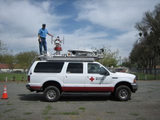
We are in Gridley, California, at the Butte County Fairgrounds (map). Our Red Cross training will be held here starting Monday morning. We arrived here yesterday afternoon, a full day ahead of schedule. Last night we had dinner in Yuba City with our friends and fellow DOVE's Don and CC Ramsey, who organized the training. This morning, we helped them and the instructors set up the classroom, and then got some of our own errands done. Tomorrow we should have a much-needed day off.
Many readers have inquired about our work with the Red Cross, and also about the ECRV's which we are about to be trained on. It has been difficult to explain succinctly what it is that we do for the American Red Cross. Yesterday, I received this link to a video program, filmed during the early days of the Katrina response, that focuses on the technology side of the response. The video is professionally produced, and a number of our friends appear in it, including Don and CC, Levi Lauvray, and Ben Byboth. It presents a very good overview of what we do and why we do it, and you'll even get to see some shots of the ECRV in action. Click here to watch the video.
I expect that I will post only sporadically while we are here in training. Next Saturday morning we will head south to San Jose to celebrate the marriage of our friends Charles and Sara, and so our next position update will be the following Sunday.
Thursday, April 13, 2006
Tempting the weather fates...
We are in Hawthorne, Nevada (map), in the free RV parking lot of the El Capitan casino here. After consulting the weather forecasts this morning, and doing some quick time-and-distance figuring, we elected to take the more scenic US95 route, rather than slog through Barstow and Bakersfield and blast up I-5, which is not only an Interstate, but one we have done dozens of times in our 20 years of living in California. We know, of course, that there is some chance the pass will be under chain control when we arrive there tomorrow, but we felt it was a small risk to travel our preferred route. Also, we are ahead of schedule, and can wait in Boomtown all the way till Sunday if need be, and the pass is rarely restricted for 48 hours straight, especially in April.
Speaking of ahead of schedule, my route planning had us arriving in Gridley sometime Saturday afternoon. Our training starts Monday morning, so that gave us one full day buffer. Between yesterday and today, we made such good headway that we are now within a day's drive of our final destination. In part, this is due to the way Delorme Street Atlas figures time -- it consistently overestimates our speeds in the east, and underestimates them in the west. Fine with us, though, since an extra day of buffer makes the Donner Pass crap-shoot more palatable.
We've heard the restaurant here is good, so we are heading in to dinner in a few minutes. Tomorrow we will continue north from here on US95. We've already done the stretch of US50 from Fallon to Fernley, so I am thinking of taking US95A instead, through Yerrington.
We have two sets of friends in Reno, but we will be there mid-day, and we want to make the pass before the next storm hits, so we will drive straight through without stopping. We'll have to catch them on our next trip through.
At a crossroads...
Several of our readers have posted comments recently, and I feel the need to respond here in the main blog. That's because I'm never sure that people who comment on any given post will go back to the comments page for that post to see if we've answered (and, in fact, we have evidence that at least some folks do not), and I don't have a good way to map comment posters to email addresses to answer them directly.
[Humorous side-note: There are at least two Ron Walkers who read the blog. I did not realize this until I took a comment post from one of them, which came into my email box courtesy of blogspot's settings, and replied, cleverly, or so I thought, to the Ron Walker that I had in my address book. Oops -- different Ron Walker.]
So let me set the record straight on a number of items:
And, to answer the last comments: Since Louise shoots the video, you will mostly hear her voice, although she does allow me to speak on occasion. The training to which we are en route will certify us as operators of the Red Cross Emergency Communication Response Vehicles (ECRV's), about which I have posted previously and will, no doubt, post again.
In other news, the FCC posted my amateur license on their web site, so I now have a call sign and am a legal operator. My call is KE7HJC, but don't expect to find me haunting the bands any time soon. I do have a dual-band handheld, though -- an Alinco DJ580 that I purchased many years ago for us on, ahem, a different band (the Alinco has jumpers for this purpose). It's been sitting in a drawer all this time, so I'll need to dust it off and reacquaint myself with it. More importantly, I will now be able to use the amateur gear in the ECRV next week during training.
Tonight we are in Laughlin, Nevada, in the parking lot of Harrah's Casino (map). Today's drive was mostly just a freeway blast across I-40, which we joined just west of Holbrook after a brief stint on US-180. (I neglected to mention in last night's post that the stop at the entrance to Petrified Forest was one of convenience -- the park itself was not on our itinerary, as we'd already done it some time ago.) We fueled up in Kingman, and headed here on US68. Harrah's has a nice steak house, and a large parking lot that is far enough from the center of the strip to be quiet. (Most casinos in town allow overnight RV parking, and there are hundreds of rigs scattered throughout town, thanks to this interim decision in the recent Clark County overnight parking flap.)
Our original route plan had us heading northwest out of Kingman on US-93, and over Hoover Dam into Las Vegas, where US-95 would carry us north to Fallon. The problem with this plan is that Donner Pass over the Sierra Nevada lies between Fallon and our final destination of Gridley, and the pass, at this writing, is under chain control. We would hit the pass sometime on Friday, when it may well be clear, but spending tonight near Lake Mead would further commit us to that route.
The logical alternative to the US93/US95/US50/I-80 route would have been to continue south and west from Kingman on I-40 to Barstow, where we would pick up CA58 over to the central valley and blast up I-5. On that route, we would have spent tonight halfway between Kingman and Lake Havasu. Frankly, though, after I-40 today we've had our fill of Interstate, and we really do not relish the idea of two more full days of it.
Kingman was too soon to stop on either route (and isn't really the most pleasant stop, either), so we decided to split the difference and continue due west to Laughlin. It will add a half hour to our total route either way, but it gives us another night to make the final decision. Tomorrow morning we will consult the weather charts and the CalTrans web site and try to determine if the pass will be unrestricted on Friday. Either way we will continue west from here on NV-163, it then being a matter of turning either north or south on US95.
[Humorous side-note: There are at least two Ron Walkers who read the blog. I did not realize this until I took a comment post from one of them, which came into my email box courtesy of blogspot's settings, and replied, cleverly, or so I thought, to the Ron Walker that I had in my address book. Oops -- different Ron Walker.]
So let me set the record straight on a number of items:
- If you posted a comment that needed a response, check back in the comments section where you posted your comment -- you may find we have posted our response there.
- If you want a direct response, via email, then either email us directly using the contact information on our home page, or update your Blogger profile to include a valid email address, and I will try to look you up that way.
- Louise and I both post to this blog regularly. I usually post text, and Louise usually posts photos and video (with text descriptions). You can tell who posted what by looking at the end of each post, where you will find a by-line such as "posted by Louise at 8:45 AM 1 comments"
- Louise is the one who has mastered the craft of posting both still photos and video to the blog, even though some of the kudos have been directed to me. She deserves all the credit for these great additions to our site.
And, to answer the last comments: Since Louise shoots the video, you will mostly hear her voice, although she does allow me to speak on occasion. The training to which we are en route will certify us as operators of the Red Cross Emergency Communication Response Vehicles (ECRV's), about which I have posted previously and will, no doubt, post again.
In other news, the FCC posted my amateur license on their web site, so I now have a call sign and am a legal operator. My call is KE7HJC, but don't expect to find me haunting the bands any time soon. I do have a dual-band handheld, though -- an Alinco DJ580 that I purchased many years ago for us on, ahem, a different band (the Alinco has jumpers for this purpose). It's been sitting in a drawer all this time, so I'll need to dust it off and reacquaint myself with it. More importantly, I will now be able to use the amateur gear in the ECRV next week during training.
Tonight we are in Laughlin, Nevada, in the parking lot of Harrah's Casino (map). Today's drive was mostly just a freeway blast across I-40, which we joined just west of Holbrook after a brief stint on US-180. (I neglected to mention in last night's post that the stop at the entrance to Petrified Forest was one of convenience -- the park itself was not on our itinerary, as we'd already done it some time ago.) We fueled up in Kingman, and headed here on US68. Harrah's has a nice steak house, and a large parking lot that is far enough from the center of the strip to be quiet. (Most casinos in town allow overnight RV parking, and there are hundreds of rigs scattered throughout town, thanks to this interim decision in the recent Clark County overnight parking flap.)
Our original route plan had us heading northwest out of Kingman on US-93, and over Hoover Dam into Las Vegas, where US-95 would carry us north to Fallon. The problem with this plan is that Donner Pass over the Sierra Nevada lies between Fallon and our final destination of Gridley, and the pass, at this writing, is under chain control. We would hit the pass sometime on Friday, when it may well be clear, but spending tonight near Lake Mead would further commit us to that route.
The logical alternative to the US93/US95/US50/I-80 route would have been to continue south and west from Kingman on I-40 to Barstow, where we would pick up CA58 over to the central valley and blast up I-5. On that route, we would have spent tonight halfway between Kingman and Lake Havasu. Frankly, though, after I-40 today we've had our fill of Interstate, and we really do not relish the idea of two more full days of it.
Kingman was too soon to stop on either route (and isn't really the most pleasant stop, either), so we decided to split the difference and continue due west to Laughlin. It will add a half hour to our total route either way, but it gives us another night to make the final decision. Tomorrow morning we will consult the weather charts and the CalTrans web site and try to determine if the pass will be unrestricted on Friday. Either way we will continue west from here on NV-163, it then being a matter of turning either north or south on US95.
Wednesday, April 12, 2006
Making videos
One of our regular readers asked how I made the videos. First of all, my new camera, a Canon PowerShot SD400, takes video. This makes it easy to upload digital moving images to the computer. I use a free program called Picasa to upload and manage both still and video shots. The still shots and video thumbnails are then uploaded to the web using another free program called Hello. Both these programs and Blogger itself were developed by the Google people, so they play pretty nicely together.
March 2009 update: Picasa has been updated so that it uploads to the web directly, and Hello is not needed anymore.
Blogger stores still photos for us for no charge, although there is a limit on how many pictures they will host. We haven't reached that limit yet; when we do, I'll have to find another solution. Blogger does not host video, however.
March 2009 update: Blogger does host video now, through Google video.
I stumbled upon this site, Freevlog, which has an easy to follow tutorial on how to post video to your blog (blog + video = vlog, get it?). If you just want the summary, here goes: convert the uploaded video from the camera using Windows Movie Maker, save in nicely compressed web-friendly format, upload to a free video storage site such as blip.tv, then link to video on Blogger. Easy, but a bit time-consuming at the uplink speeds our Datastorm provides.
I tried to use Freevlog's suggested video storage sites, OurMedia and Internet Archive, but was not successful. Supposedly the Internet Archive will store the video forever. I'm not sure what blip.tv's policy is. It is unclear on their site. Blip.tv is still in beta, so it could disappear tomorrow. For now, though, as I practise this whole video thing, it is good enough.
March 2009 update: Blip.tv seems to be going strong. They've improved their format, and I've been satisfied with them. I've tried YouTube and Google video, but keep coming back to Blip.tv.
Real petrified wood and fake teepees
Just a quick update tonight, because it is late and I am tired. Besides, Louise has already beat me to it, with photos and video below.
We are at one of the cheesy souvenir and rock shops that flank the south entrance to Petrified Forest National Park (map). This one has a campground, with perhaps two dozen "sites," six of which even have electricity. Camping here is free -- an effort, I assume, to drum up business. If you use the electricity, it's $10 (we are in a no-hookup spot). From the looks of the "campground," it was intended to be a revenue adjunct to the shop, but I am guessing it never made any money. The other drum-up-business scheme here seems to involve a half dozen beater cars scattered throughout the parking lot, so the place looks like it always has customers. Tomorrow, we will stroll into the shop and perhaps buy a postcard.
After leaving our pleasant spot along the Rio Bonito this morning, we soon came to the small town of Capitan, which bills itself as the birthplace of Smokey the Bear. While Smokey originated as the now famous cartoon bear in 1944, a black bear cub orphaned in a forest fire in the nearby Lincoln National Forest six years later was given that name by a ranger, and soon became the real-life Smokey, who went on to live 26 more years at the National Zoo in Washington, D.C.. We stopped at the small museum dedicated to both the icon and its incarnation in town.
From there, US380 brought us to the Rio Grande valley. After crossing the river, we made our way into Socorro, where we picked up US60 west, which brought us over the great divide. Toward the western edge of the state, on the plains of San Agustin at nearly 7,000' elevation, we encountered the National Radio Astronomy Observatory's Very Large Array. Naturally, we had to stop in at the visitor center and take the short self-guided walking tour. This marks the third astronomical observatory that Odyssey has visited (along with the MacDonald observatory in Texas, and the Lick Observatory in California). At this one, I think Odyssey developed a case of dish envy. I won't post much more about it, since Louise will be posting some photos and maybe some video, and you can click the link above to go to their site.
Crossing into Arizona has thrown our biological clocks for a loop -- we just barely entered the Mountain Time Zone and have been adjusting ourselves to Mountain Daylight Time for only a day. Arizona, however, does not observe Daylight Savings Time, and thus we adjusted our clocks back yet another hour this evening. The clock says it's 11:30, but my body thinks it's 1:30 in the morning. I'm hoping I'll be back in synch by sometime tomorrow evening...
Tuesday, April 11, 2006

Video: a 360 degree panorama of this campsite. If you aren't interested in the video, don't click on the picture. While I'm experimenting with the video uploads, I'll probably really overdo it with the goofy narrated films. Remember, this website is primarily developed for our parents, who love to see their kids on film...

Monday, April 10, 2006
All Your Base Are Belong To Us
We had a pleasant and uneventful night in Sterling City last night. It was dark, quiet, and secluded. A few golfers showed up this morning, but no errant tee shots hit Odyssey.
Today we continued northwest on US87, stopping for 175 gallons of diesel in Big Spring, TX, where US87 crosses I-20. (Texas has the cheapest diesel we will see for the rest of the trip.) 87 took us into La Mesa, where TX137 then took us to Brownfield and US380. 380 took us into New Mexico and through Roswell, where we were decidedly not abducted by aliens. In fact, most folks in Roswell stared at us as though we might be aliens, which prompted the whimsical title of today's post.
Somewhere around the Texas line, we crossed into "the west." There is a marked change in scenery, from endless farmland to undeveloped scrub desert, and the feeling is unmistakable. Not far west of Roswell, the high plains give way to more hilly terrain, and we have been climbing steadily to this point, on the outskirts of the Lincoln National Forest (which is, perhaps, where Lincoln Logs come from). Just before we stopped for the night, we passed through the historic burg of Lincoln, NM, now almost a ghost town.
Tonight we are bivouaced at the "Double Crossing" picnic area (map). I'm not sure if that refers to the fact that a perennial stream merges into the Rio Benito here, or some more nefarious dealings of Billy The Kid, who inhabited these parts. This spot is also dark, quiet, and secluded. Tomorrow we will cross the continental divide, and should end our day somewhere in eastern Arizona.
Sunday, April 9, 2006
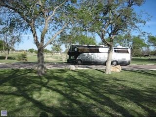
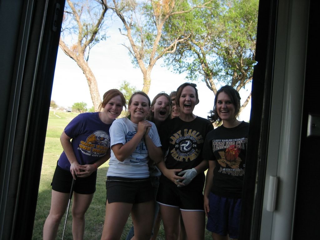
A hush falls over the gallery at the Masters...
We are stopped for the night at a roadside picnic area in Sterling City, Texas (map), nestled in between the 6-hole municipal golf course and the Dairy Queen. When we pulled in, the high school girls' golf squad was practicing on the links, and the whole lot immediately cruised over to Odyssey to see if anyone famous was aboard. They were so enthusiastic, we were sorry to have to disappoint them. Louise took a photo of them out our open entry door, posted below.
We spent the next half hour or so relaxing in our lawn chairs, sipping wine, and watching them practice. Apparently, they have a district tourney tomorrow. We imagined ourselves with VIP passes to the LPGA... (And yes, in regards to the title, I do know that the Masters is a men's tournament -- I just couldn't resist capitalizing on current events.)
We had a pleasant drive from Austin, a large part of it through the rolling Texas hill country. State route 71 is fast, uncrowded, and scenic. We had a bit of a late start, since we had some email and business to catch up on before we left.
Speaking of business, I do have a schedule update. We have booked ourselves on another trip to Cancun, since we have some friends who are going at a time that was good for us. We fly out of Houston on May 29th, returning there on June 3rd. Other friends have property in Houston, complete with hookups, for Odyssey to spend the week without us. We just need to find a good kennel nearby and we will be all set.
Of course, this means that, after California, we will be heading more or less right back this way sometime in May. We'll have more time in transit, though, so we will take a more circuitous route -- the route we are on now is, essentially, the shortest non-interstate route to Gridley.
Video!
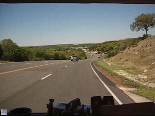
I finally figured out how to put video on the blog, officially making Our Odyssey a vlog. Clicking on the image will play the video, which is compatible with Windows Media Player and other programs. This one is a Dash Cam clip, short and sweet to test both our uploads and your downloads.
Saturday, April 8, 2006
Quick update from training class...
It's been a while since I posted, mostly because we have been very busy here at our Response Technology training class. I suppose I should have mentioned to everyone that this was likely to happen -- the seemingly abrupt end to postings last week apparently concerned some folks.
In any case, all is fine and we are still here in Austin. We are parked at the Red Cross technology maintenance center, where there is, conveniently, a 50-amp power outlet. I'm not going to post the map link, even though the address of the maintenance center isn't all that hard to find on the net. We have been here since last Saturday -- I moved Odyssey directly here from my last digs over by Lowe's, then borrowed a Red Cross rental car to pick Louise up at the airport.
Class started first thing Sunday morning, and ends tomorrow afternoon, making for a full seven days. We have generally started at 8:30 every morning, and regular instruction has ended sometime after 5pm, after which we have been involved in various evening social activities with the other students. Generally, we have headed right to bed after arriving back here each evening.
Last night was the big exception: Louise headed downtown with some of the other students for Austin's famous "First Thursday" event, while I and ten other students sat through the amateur radio Technician Class License exam. All eleven of us passed, so yours truly is now a licensed ham.
Today our US mail also caught up with us here, and we learned that we are being audited by the IRS for the first time in our lives. We will need to call the examiner first thing Monday, since we are already late: the letter, mailed on March 15th, requested we reply by March 30th. I am guessing that the whole life-on-the-road thing is just too weird for the IRS and sets off all sorts of audit flags, so I am not too surprised.
In other news, one of our fellow students was dismissed this afternoon because they absolutely needed to deploy someone to the tornadoes in Tennessee. This prompted us to look at the maps -- it looks as if they missed all the folks we know in that state, but they did hit some areas we've traveled through. Our hearts go out to those affected by all the tornadoes.
As I have posted here earlier, we are scheduled to be trained on the ECRV's in Gridley, California in another week (the principle reason we were not deployed to the tornadoes ourselves). In order to be there on time with a relatively comfortable driving schedule, we will leave here first thing Sunday morning and proceed directly to Gridley via the most direct route, with a planned arrival a week from tomorrow. I don't expect to get another chance to post while we are here, so you will next hear from us somewhere en-route.
Subscribe to:
Posts (Atom)