Monday, July 27, 2020

Pilgrims' Progress

We are underway in the Atlantic Ocean, bound for the bustling seaport of Gloucester, Massachusetts. The forecast was for two footers today, but so far it has been calmer than that. We are on a rhumb line from Plymouth Light, and Massachusetts Bay will be off to port all day. We are skipping Boston and its environs on this pass. It's 100° today, a good day to be underway with the pilothouse A/C running.

Shortly after I last posted here, we tendered back through the hurricane barrier into New Bedford harbor and landed at the town dinghy dock, behind the lightship Nantucket. We walked a few blocks along cobblestone streets into the historic old town in search of safe-looking outside dining, which we found at the Moby Dick Brewing Company on Water Street.


Vector at anchor in Plymouth Harbor.

The name is a nod to the city's extensive whaling history, which is memorialized all over town, but especially in the New Bedford Whaling National Historic Park, which comprises the old downtown, wherein we found dinner. After finishing our decent meal with house-brewed ale, we strolled the district a little, passing the Whaling Museum on our way back to the waterfront.

Shortly after returning to Vector, another vessel came into our anchorage, the 145' OSV/survey vessel Danielle Miller. They dropped the hook close enough that we could hear her generators all night, and her decks were well lit. Other than that, it was a calm and peaceful night.


Flux tied up alone at the dinghy dock, in front of the light ship. Louise very stylish in her mask.

In the morning I pulled the last remaining start battery out, loaded the two batteries and our folding "schlepper" into the dink, and headed back into the harbor and the Gifford Street boat ramp dock. I also brought the e-bike and a backpack along, leaving them locked in the tender while I walked the batteries over to Advanced Auto Parts.

The walk wasn't too bad; I stayed mostly in the street for a less bumpy experience than the sidewalks with the little cart's small wheels. I did have to go up and down a bit of a hill, but overall not too bad. They had my batteries ready and waiting and the exchange was quick. Oddly, one battery bore Advanced's "Autocraft" brand like the ones I brought in and the other, clearly identical battery was a Die-Hard.


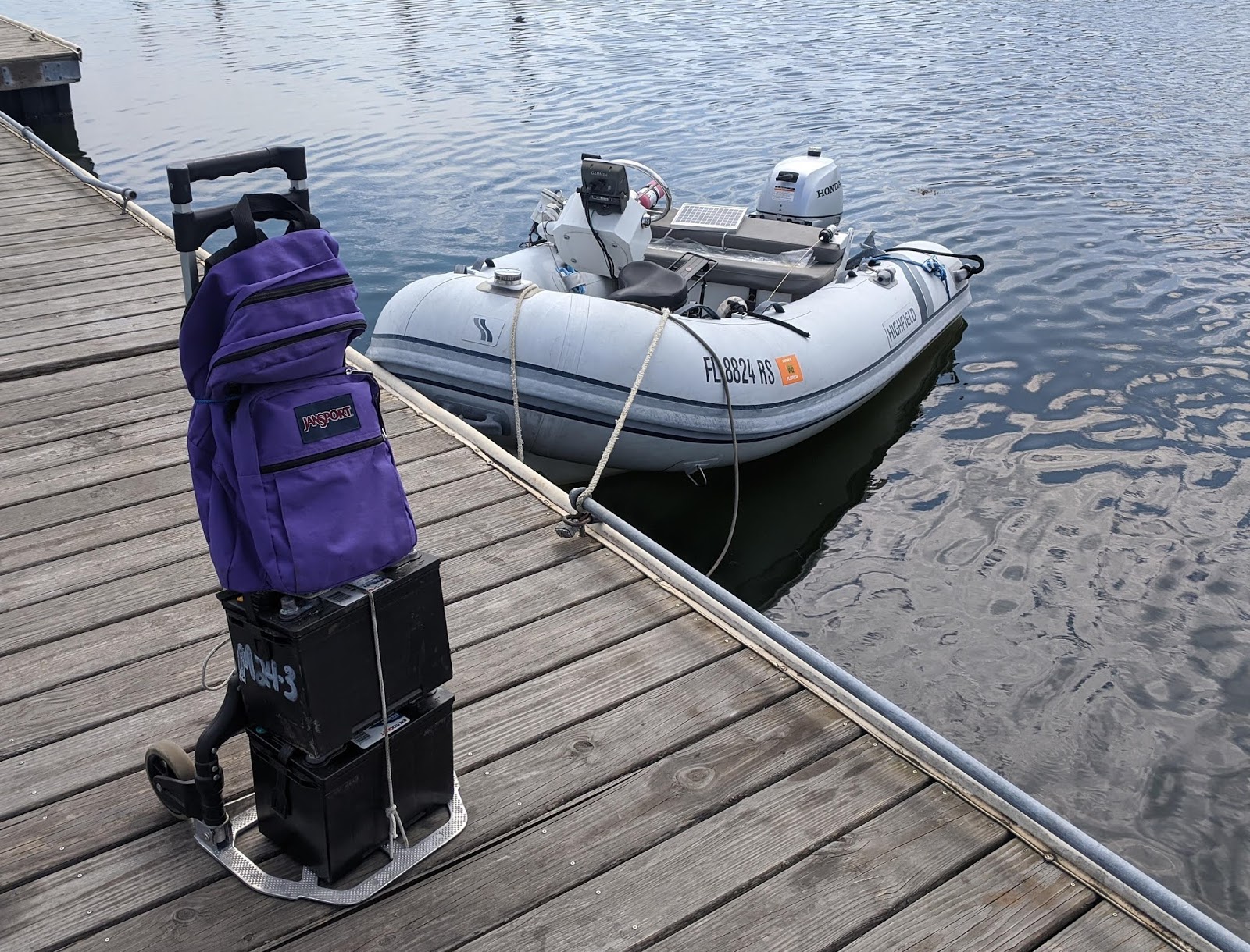
Old batteries ready for transport. You can see the e-bike still folded in the tender.

After returning to the dock, I locked the new batteries under the tender seat, unfolded the bike, and set out for the Save-a-Lot store, within which was the Amazon locker. I picked up my packages and then filled our provision list, a challenge at this store. Still, it was right there, and with weather moving in, I did not want to take the time to ride even further to a better store. I was able to fill most of the list, and at least the prices are good.

I should mention here that, after posting about the need for new batteries and our plans to divert to New Bedford to be able to get them in walking distance, a number of folks reached out with offers to drive me to the store for batteries at one port or another.  And, while we were in Newport, friends who live in the area offered to come pick us up and feed us a home-cooked meal; I'm quite certain they would have swung me by the auto parts store, too.


This old street would have been miserable on the cart's little wheels, except someone paved me a cart path.

While the offers are greatly appreciated, and oh, how we would love to sit down to a nice meal with good friends in their own back yard. we're not yet ready to get into an automobile. We're trying not to spend much time in enclosed spaces of any sort, including public restrooms, stores, or even the short trip from the front door to the back patio at many restaurants. Enclosed vehicles of any stripe are not in our near future. That goes for planes, trains, buses, enclosed launches, and even the automobiles of our own relatives.

I hadn't really thought about it until this came up, but reflecting upon it, the last time were were in a car was exactly five months ago, back in February, when we took a Lyft back to Vector from the Enterprise car rental in Fort Lauderdale. The rental car had carried us to Orlando and back for a visit with family, and then we used it to load up on provisions for what we thought would be three months in the Bahamas.


Harpoon launcher outside the Whaling Museum.

We are very fortunate to have our pair of motor scooters on deck. That allowed us to do a lot of errands and provisioning in Jacksonville after we returned from the Bahamas without having to use transit, ride sharing, or even a rental car. When the end came for our cat, we had to find a vet to which we could walk from the dock.

At some point we may find ourselves with no choice, particularly if either of us needs medical care. But for now, we're minimizing risk by staying out of vehicles. That goes both ways: we've been in three states in the last two weeks, and in tourist-laden spots in each. We don't want to be unwitting carriers and expose our family or friends any more than we want to be exposed ourselves.


At the boat ramp lot I encountered new-driver training for the local school system, which I gather is planning to open.

I made it back to Vector in time to beat the incoming weather, and we stowed the provisions and e-bike and decked the tender as quickly as we could. I was a little sad to be leaving New Bedford so hastily, as there is a lot of history there and we would have enjoyed another night or two. Not enough, mind you, to pay $45 a night for a mooring ball, though, and things would soon become uncomfortable outside the barrier.

What we needed for a comfortable night was protection from the south, and so after weighing anchor we proceeded around the corner to the east, hoping to get behind West Island for the night. Studying the chart, it seemed like the bottom might be too rocky there for good holding, and so we instead continued another few miles to a familiar anchorage at Mattapoisett, Massachusetts (map). We checked in with the harbormaster, dropped our hook in the designated spot just as last time, and had a comfortable night. We did not go ashore.


Not sure if this was a bad sign.

Friday morning we got an early start, to have a favorable tide through Buzzards Bay, the Canal, and into Cape Cod Bay. At under 65', we are not required to get clearance from Canal Control, but we called then anyway at the Hog Island buoys to get a traffic check. We had two knots on our stern at the entrance, and closer to three mid-canal, making it a challenge to keep below the 8.5kt canal speed limit.

That speed limit did not seem to faze a number of pleasure craft, including a large downeast that passed us on full plane with a large wake. Before he got out of site he was pulled over by the Canal patrol boat, who clearly lectured him for quite a while. They let him go just as we reached them, and he immediately cut across our bow. He got his comeuppance when he launched violently off a wave in a rough section where strong wind against the three-knot current had the canal churned into steep four-footers. We had to dog everything down.

We shot out of the canal by lunch time, and with conditions on the bay a bit uncomfortable for anchoring in our customary spot off the beach, we continued to the next protected spot, the twin harbors of Plymouth and Duxbury. At a tide of +9' and rising, we cut a few corners on the entrance and whizzed into Plymouth Harbor, where we dropped the hook in the only available anchorage, well outside the breakwater on the eastern edge of the harbor (map).


A rock.

Plymouth is a giant tourist trap, and the enormous harbor with hundreds of moorings makes it a popular weekend and day-trip destination for go-fast boats from all over the state. Anchored outside of the no-wake zone, we knew it would be a somewhat bouncy weekend. But we prefer not to move on weekends if we can avoid it, because traffic is horrible and finding a spot to anchor in New England can be impossible. Well-anchored in a good spot, we decided to just hunker down for the weekend.

The worst wakes were from the giant high-speed whale watching boats, perhaps a half dozen times a day. We were far enough from the channel that the really little boats hardly bothered us. And it was dead calm at night in the protected harbor. We had a mostly comfortable and pleasant three nights. We managed to get ashore for walks daily, and we went out for dinner twice, with good people-watching.


Mini-protest on my way into town.

The local museums are closed, but the rock is, well a rock, and there is lots of history here, even if it has been co-opted by the tourism industry. On Saturday I came across a mini-protest, with BLM supporters on the Coles Hill side of water street, and Trump supporters across the street in front of the rock, each group trying to garner support from passing cars. Coles Hill is also the site of the annual Thanksgiving "day of mourning," near the statue of Massasoit.

The Mayflower II, incidentally, is not in town; we tied our dinghy up right near her berth. She left Mystic Seaport on the 20th after a three-year refurbishment there, but she went to New London for crew training and sea trials before she returns to Plymouth. I'm sorry we did not cross paths on the water (we were in Newport when she left Mystic), as it would have been nice to see her under way.


This plaque near Massasoit speaks for itself.

Update: we are anchored in a familiar spot in Gloucester harbor (map), and in a few days we should be in Portsmouth, where we will visit my cousins, the same ones we saw in Orlando. We'll be practicing social distancing, and we're still working on picking venues to meet up that do not involve conveyances. This will be the first family either of us has seen since the pandemic began.

I've ordered new batteries sent to their house for them to bring to us. Unlike our last set, weighing in at half a ton, the new batteries are Lithium Iron Phosphate (LiFePO4) and will come in at under 100 pounds for the four of them, so I had few qualms about asking them to cart them for us.


A view from Coles Hill over the rock and its colonnade out to the harbor. Vector is a tiny dot above the colonnade. Protest in the foreground; the Trump support is pretty thin.

At some point in the future I will do a complete write-up on the LiFePO4 project, which is very much a work in progress and is being driven by our AGM Lifelines being prematurely at end-of-life. But for the curious, we went with the Lion Energy UT1300 items, because we can fit all four of them in an existing compartment under our settee. I got a good deal using a discount code, and you can do the same by ordering from this affiliate link, which will get you 15% off list direct from the manufacturer.

I'm still working on ordering all the pieces and parts needed for the project, including a bunch of 2/0 battery cable, terminal ends, switches, and the like. With any luck I should have everything I need by the time the batteries arrive in a week or so. Stay tuned.

Wednesday, July 22, 2020

New England at last

We are under way eastbound in Buzzards Bay, headed for New Bedford, Massachusetts, with Rhode Island behind us. We have a short window; seas today are a rolling two feet or so, but they deteriorate starting tomorrow.

Friday night after I finished posting here, I was finally able to get a glimpse of Comet Neowise, the light pollution of Connecticut notwithstanding. It was barely visible with the naked eye, and quite clear in my binoculars. I'm glad I saw it, because it's been cloudy every day since.

We woke Saturday morning to dense fog in our little cove. From the radio traffic it was clear the fog extended all the way across the sound to the Connecticut harbors, and around the corner through Plum Gut and into Orient and Peconic Bay. Fortunately, the uncomfortable swell that had been with us well into the evening had settled as night fell, and by morning we were comfortable, so we could wait for the fog to lift.


Passing the (modern) tall ship Oliver Hazard Perry and Fort Adams on our way out of Newport this morning.

It was 11am before we had enough visibility to get under way, about a quarter mile, with the forecast saying it should have lifted by 10 or so. Not long after leaving the cove and into the main part of the sound, it dropped again to less than 1/8 mile, and then even less. We engaged the automated fog horn, adjusted the radar, and kept a sharp lookout all the way to the gut.

Things finally started to clear a bit as we approached Orient Point Light, just in the nick of time for me to do a pas de deux with the enormous superyacht Excellence, who appeared out of the fog on my port side. We had seen her well out on AIS (and heard her even louder foghorn) and made arrangements by radio, but still she passed astern of us by less than a boat length (hers, not ours). Once we could see her, I recognized her from several photos recently posted online.

We shot through Plum Gut with three knots behind us and steered for Montauk, thankfully in decent visibility. The fog delay in our departure meant we'd be arriving at the inlet at dead low tide, and we briefly contemplated anchoring instead in the cove to the west called Fort Pond Bay, a popular day anchorage adjacent to a highly rated lobster restaurant with a dock. Ultimately we decided to make Montauk Harbor and drop a lunch hook, if need be, to wait on tide to get into the lake.


The 260' yacht Excellence emerges from the fog. Standing joke on the Internet is that she was built upside-down (zoom in on the bow).

The Coast Guard had been making announcements all morning about a hazardous debris field off Montauk entrance, consisting of a couple dozen crates and a sheen. We never saw it, though, and had an uneventful cruise all the way into the harbor, passing a giant line of RVs camped on the beach for the weekend. We found a pocket of depth off-channel at the very sound end of the harbor and dropped the hook, just a few hundred feet from Gurney's Resort (map). That was good enough for overnight, and we no longer had to worry about picking our way through the shallow channel into the lake.

Our friends on the South Fork, whom we had hoped to see at least briefly while in town, had other commitments in the evening, and we ended up booking a table at Showfish restaurant at the nearby resort for just the two of us, on a nice outside patio. Consistent with Montauk and East Hampton in general, this was the most expensive meal, bar none, that we have had since returning to the US. Other than the price, it was unremarkable, but we were glad for the opportunity to get off the boat.

After dinner we took a short stroll around the grounds. We had to dodge a groundskeepers golf cart as the young man was distracted by a powder blue Lamborghini backing out of the parking lot; this is the essence of the Hamptons. Vector with her rust stains, the only boat anchored in the harbor, did not really fit in with the array of mult-million-dollar yachts and million-dollar runabouts filling the harbor. Most of the riff-raff was anchored in the lake, ironically abreast of the tony Lake Club.


Vector, from our table on the patio at Showfish.

We were glad to have seen it, and it's nice to be familiar with the closest protected harbor to Montauk Point, whose sometimes extreme conditions are belied by the pair of USCG Motor Lifeboats stationed here. But one night was plenty, and with a short window of good seas, we weighed anchor first thing Sunday morning to cross to Rhode Island. We had to dance around a large sailing cat that had come in after dark and dropped their hook right next to us.

Our plan had been to head to the Great Salt Pond anchorage on Block Island. This anchorage is sort of party central on the weekends, at least in normal times, but we had hopes that it might be a bit quieter after Sunday night, and it's a fun place to just sit on deck and watch the shenanigans. But the forecast had deteriorated for the coming week, and if we stopped at Block Island, it looked like we would be there for three nights, which is a bit much. Instead, we set a course for Narraganset Bay and Newport.

Fog had been moving in as we weighed anchor, but we had good visibility leaving the harbor. That soon changed, and just a mile or two out, I again had to switch on the fog horn. We ran the horn for the next three hours straight. Despite visibility of less than 1,000', we did not hear a single other fog signal, and of the myriad small boats that came zipping out of the fog bank right at us, only perhaps one in 50 had its navigation lights on.


Sunset over Gurney's Resort, Montauk. Lighthouse is fake; restaurant is at left. Lots of spendy boats, including the 86 Nordhavn Divemaster, flying a rainbow-striped US flag mimetic.

The direct route from Montauk to Newport intersects the direct route from Block Island to Fisher Island Sound, the return path to all destinations along the Connecticut coast. As we approached that intersection, the conga line of weekenders returning from Block Island started coming fast and furious. We could see maybe 5% of them on AIS, and perhaps three quarters of them on radar, but the rest just appeared out of nowhere. No lights, no fog horns, and for many, no radar, but zipping along on full plane in near zero visibility. Our Kahlenbergs might well have been the only thing keeping us safe.

Visibility finally improved just as we rounded Point Judith into Narraganset Bay. Good thing, because on a Sunday afternoon, the bay was chock-a-block with sailboats out for a day cruise. In open water, we have to avoid sailboats under sail alone, there is no negotiation. And in a crowded sailing area on a slow boat, that can be a challenge. I hand steered the rest of the way to the harbor.

Newport harbor is always crowded during the season, and with most of the available water peppered in mooring balls, there are not a lot of places to anchor. Nevertheless we found a clear spot, and dropped the hook just off Lime Rock and the Ida Lewis Yacht Club (map). Our previous spot, north of Goat Island, would not have been suitable in the coming southerlies.


Newport harbor from our anchorage. The wide angle does not do justice to how close together the boats are.

This was a great spot for three nights, well protected and an easy dinghy ride to town. I was surprised by the amount of tourism, with only perhaps two thirds of tourists masked walking through town. Masks seemed to mostly be enforced in restaurants and shops, and all the staff were wearing them. While indoor dining is open here, we still only felt safe on well-spaced patios, and we enjoyed sidewalk dining at the Surf Club, eating on the patio at The Landing on Bowen's Wharf, and eating in a bank parking lot (really) adjacent to old standby Perro Salado. In honor of National Ice Cream Day we bought cones on the wharf Monday.

I spent the bulk of my time trying to bring resolution to our battery problems. At least one day, we ran the gen for seven straight hours while I charged and equalized the house batteries, really to no avail. They're just done, prematurely, and I spent numerous hours researching LiFePO4 alternatives to replace them. On top of that, our starting batteries have given up the ghost after nearly six years (a good run); I removed one of the pair, which was completely bad, but the remaining one is not enough to start the main engine on its own.

While the house battery issue will have to simmer until we have a good shipping address, at the expense of increased generator run time, the starting batteries just need an Advanced Auto Parts store. There's one in Newport, but no good way to get there without getting on a city bus, which is off the table for the time being. And thus it is that we are headed to New Bedford, where I can cart them on our hand truck the three quarters of a mile from the dinghy dock. We also ordered a few items to the Amazon locker in town.


Bella Vita. Again. There is no escaping her.

We had one night where we caught another glimpse of the comet, this time over the Claiborne Pell suspension bridge. And while I can't capture it on my phone, the harbor lights are delightful at night. At least ten sailing yachts in the harbor are tall enough to require a red light on top, per FAA rules. Harbor tour boats passed us close aboard several times daily, and we even took our own little harbor tour in the dinghy, where we discovered that Bella Vita, who has been shadowing us all over the country, is here too. Every day we were also surrounded by a fleet of Optis helmed by pint-sized sailors from the nearby yacht club sailing school.

Update: We are anchored in the "outer harbor" of New Bedford, in federal anchorage A (map). We went all the way to the inner harbor, through the open Tainter gates in the 60's-era hurricane barrier, only to find that anchoring is no longer permitted anywhere in the harbor. We did not want to pay for a mooring, and it's calm enough out here, at least for tonight, to anchor. Later we'll tender the mile or so back to town to check things out and maybe find some dinner.


Approaching the New Bedford Hurricane Barrier.

In the morning I will be schlepping the two old start batteries over to Advanced Auto, where the two replacements are already waiting with my name on them. And in a separate trip, I will take the e-Bike to the Amazon locker and the grocery store to reprovision. Seas are supposed to pick up after tomorrow, so we may end up moving to the next bay east for better protection.

Friday, July 17, 2020

Long Island is aptly named

We are under way eastbound in Long Island Sound. We're running along a part of the north shore of Long Island that is devoid of bays, coves, or harbors, and we have our sights set on the next usable anchorage, in a little cove off Truman Beach, in Southold.


One World Trade Center as seen through the fins of The Oculus

Tuesday we went ashore for breakfast outside at our favored bagel joint. Having checked the tide tables to determine that Wednesday was perfect for departure, we paid for just one more night at the anchorage. After breakfast I returned ashore with the fully charged e-bike to do some more exploring.


USS Intrepid museum. We could see her superstructure from our anchorage.

I rode all the way down to the Battery on the very nice riverside bike trail that runs the length of the island. I diverted a block east to the World Trade Center, where I found the 9/11 memorial fountains completely fenced off. The Oculus was eerily silent and empty; as a mall it is closed, but it is open for transit riders, where it serves as a giant interchange. On a weekday in the financial district, with no tourism, it hosted but a small handful of riders. It was open for entry, but I am avoiding unnecessary indoor spaces.

The entire district was empty. Wall Street was a ghost town, the Charging Bull standing as a monument to American hubris. I miss Fearless Girl standing in defiance on Bowling Green. I continued into Battery Park, around Castle Clinton, and worked my way back north through Battery Park City. I was struck by how empty the harbor was.


9/11 Memorial fountain as seen from The Oculus. 1WTC at right.

The restaurants along the waterfront were all open for patio dining and were doing a brisk business for a weekday afternoon. The marina, not so much: it was empty. I am not sure if they have closed their transient dockage, or simply have no takers. I continued north on the bikeway to midtown, where I again made a brief detour a couple of blocks east to the new Hudson Yards development. It all looks quite nice, and I look forward to going in, should it ever again be safe to do so.


Looking down into The Oculus. Normally this floor would be packed with people.

My battery thankfully lasted all the way back to the dock, after a ride of perhaps 12 miles. The bike is nominally rated for 15. I was back on board, bike in hand, well before cocktail hour. We returned ashore in the evening for one last meal, at ho-hum Italian place Salumeria Rosi, and to restock some fresh provisions at the Fairway market before returning to the boat.

Wednesday morning we decked the tender, and at an appropriate time in the tidal cycle, we weighed anchor and cruised over to the dock to take on water. The weird nature of hydraulic currents around Manhattan meant that, in order to have a fair tide all the way around the island and out into Long Island Sound, we were docking at near max current, bow headed upriver. That aced us out of also pumping out, which is on the port side. It took over an hour to fill the water tank, during which time we also offloaded the trash and recycling.


Looking across the harbor at Lady Liberty and Ellis Island from The Battery. Anyone who has been here will be struck by the fact that there is not a single vessel to be seen in the harbor.

Our timing was impeccable, and we zipped down the Hudson, around the Battery, and right back up the East River with anywhere from one to two knots behind us. An old high school chum lives on the Upper East Side in sight of the river; a year or so ago we had agreed to try to connect the next time we came through. Little did we know. In lieu of an actual meetup, he waved to us from shore and took a few photos as we steamed by. I had just enough time to wave before having to turn my complete attention to the helm..


Vector at the dock for water, amid a sea of rusty moorings.

We hit Hell Gate with three knots behind us. The confluence of three hydraulic channels, with an island in the middle to boot, makes for a swirling maelstrom of eddies and countercurrents that roll the boat and can spin it around if not paid attention to. I'm used to it now, and fortunately there was no other traffic and I could follow my preferred line. We had a nice push all the way to the sound, past all the usual landmarks.


The high-zoot North Cove Marina in Battery Park City was empty.

Normally on this leg, we would stop at Port Washington on Manhasset Bay. In addition to a nice anchorage, they have a mooring field which offers two free nights, a launch, a pumpout boat, and two free dinghy docks with access to a nice grocery store and a few restaurants. As with so many of our usual stops, we felt no need in the Covid era, and so we decided to forego the four-mile detour into and back out of the harbor, and availed ourselves of what was left of the tide to get a bit further along.


"The Vessel," an interactive sculpture of staircases and balconies.

That had us dropping the hook in a small cove between Matinecock Point and Peacock Point (map), where we had a nice sunset, and a view of the beachgoers on Pryibil Beach. We had a nice dinner aboard and a very calm, quiet night. I hoped that we might see Comet Neowise once away from the city lights, but it was too cloudy.


Vector steaming up the East River, passing Roosevelt Island. Photo: Flash Sheridan

Yesterday we got an early start, intending to make it a long day and get all the way here. The forecast was for one footers on a long period, perfect conditions. The forecast was also for five knots of wind, but we soon had treble that under way, and  as we angled further and further from the shore. conditions got uncomfortable, with steep two footers on a short period.  We're not in a rush, and so rather than continue to bash through them, we angled back to shore to seek shelter, before the long harborless stretch of shoreline.

I set a course for the last harbor in the eastbound direction, which looked to be easy in and easy out: Mount Sinai Harbor. I knew we'd find it chock-a-block with mooring balls, but figured we'd find a spot to drop the hook -- the harbor is enormous. Turns out I figured wrong; while perhaps a third or more of the moorings were empty, they had still planted a ball in every square meter of harbor that could hold a boat.


One WTC as seen from Brookfield Center in Battery Park City.

Reluctantly, we beat a retreat and backtracked three miles to Port Jefferson Harbor, where I had to squeeze in line between a loaded tow and a car ferry to run the inlet. We pulled off channel just inside the harbor, headed for the eastern shore away from the ferry wakes, and dropped the hook (map). This turned out to be a popular watersports area, and on a sunny day we were circled by all manner of jet skis, wakeboards, Big Mables, and center consoles. By sunset they had all departed, and we had the corner to ourselves for the night, another quiet and peaceful stay. After dinner I got a much needed haircut on the swim step.


Sunset over western Long Island Sound from Peacock Point.

This morning we got another early start, and have had the excellent conditions that we had hoped for yesterday. It's a straight shot down the bay all the way to the little cove just off Truman Beach, where we have anchored in the past. We're hoping for another peaceful night.

Update: We are anchored off Truman Beach (map) in Southold, New York, on the North Fork of Long Island. It was weird passing our friends' vacation home on the bluff just a half hour before arrival; normally we are here in this vicinity to visit them, as we have done most years since moving on the boat. They're stuck in California for the duration, and I detected a bit of envy that we are here in this neighborhood.


Gratuitous shot of a mooring where the eye had worn so thin, they welded a shackle in place to reinforce it. We always trust our own ground tackle more than moorings.

Unfortunately, our hoped-for quiet anchorage, while mostly settled, has had an uncomfortable motion to it from swell wrapping around the point. Louise was so uncomfortable that she took some meds. It's a little better now than it was earlier and through dinner. We'll weigh anchor first thing in the morning.

Normally, when our friends are in town, from here we would go around the corner into Gardiner's Bay and the Peconic River, landing somewhere in the Greenport area. With there being no point to that now, instead we will cut diagonally across to Montauk tomorrow, and make our way into the harbor and Lake Montauk. We have some friends on the South Fork as well, and if the stars align, we may be able to have a socially-distanced reunion of some kind.

Monday, July 13, 2020

These vagabond shoes ...

New York, New York. A few weeks ago, the epicenter of the Covid-19 pandemic in the US. We should be avoiding it like the plague, if you will pardon the expression. And yet we have felt safer here than anywhere else we've been ashore in recent weeks. No one here questions the reality. Everyone is masked. Everyone is being careful and respectful.


This view of an empty street corner at Radio City Music Hall seems post-apocalyptic to me.

The rest of our passage was uneventful, and I turned in shortly after 3am Thursday morning. Normally I sleep until 9, but Louise rousted me at 7:40 -- we were in pea-soup fog, and she needed extra eyes on the bridge. Also, we had to run the automatic foghorn, which will wake the dead as well as the off-watch. That did not stop myriad center consoles zooming out of the fog and passing us close aboard before we could even pick them up on the radar.


Approaching The Narrows, having just emerged from the fog. Cargo ship at left passed us.

I had to make crossing arrangements with a Coast Guard cutter in the Sandy Hook channel, and alter course to cross the Ambrose channel well ahead of a cargo ship, but we made good time with a following tide, and when we arrived at Gravesend Bay, we elected to simply keep going to our intended destination here in the Hudson.


A view of Lady Liberty, through the haze, like none other I have seen: without a single visitor.

I have never seen New York Harbor this quiet or this calm. It was still hazy as we approached the Statue of Liberty and The Battery, but I snapped photos nonetheless; a daytime view of the statue that I have never seen: devoid of tourists. Governor's Island was still closed, as was Ellis Island. The Jersey City waterfront was eerily quiet. The unending parade of high-speed ferries was down to a trickle. And we passed the enormous Circle Line tour fleet and numerous other tour boats all bottled up at their berths.


Obligatory shot, again through haze, of lower Manhattan. Governor's Island to the right.

Two hours after entering the harbor, we arrived here at the West 79th Street Boat Basin, where we dropped the hook just a few hundred feet north of the marina, roughly abreast of West 83rd Street (map). We have the entire anchorage to ourselves; not a single other boat has anchored since we arrived. Even the marina docks are half empty, despite being 100% rented (the waiting list is years long).


We passed Pier 55 Park under construction. Zoom in to see the funky concrete pedestals.

We have never been able to anchor this close to the dock. Normally there are mooring balls extending north through the designated anchorage for three quarters of a mile; in the past we've had nearly a mile tender ride to get ashore. But the pandemic prompted a decision to forego installing the moorings this season, and all the anchors, chains, and floats are still sitting on the pier, ready to be deployed. Now that we've actually seen the mooring anchors, we get why they won't let our big, heavy boat use one.


Seasonal moorings neatly lined up on the pier.

Along with having the entire anchorage to ourselves, we've also had the entire dinghy dock to ourselves. In years past, the dinghy area has been so chock-a-block with boats, mostly just stored there waiting for their owners to need to go out to their moorings, that Louise has had to lean over the bow and pry them apart so we could get to the dock. The whole Boat Basin experience has been rather surreal.


Flux looking lonely in the tender area. Normally the docks on both sides are full. Empty slips in the background.

Knowing that Tropical Storm Fay was still bearing down on us, and that we'd likely be trapped on the boat all day Friday, we splashed the tender ahead of dinner time and headed ashore. After tying up at the gloriously empty dinghy area we walked to the office, which had replaced one of their exterior windows with a piece of Plexiglas with a slot in it. They have not gone touchless, but now they hand you the forms to fill out through the slot, and take your payment that way. They still have to come out of the office to let you back into the gated marina when you ring the bell upon returning, though.


Vector alone in the anchorage, beyond the icebreakers, as seen from the docks. Line of ATBs to the left are anchored.

Contributing to the surreal experience is the fact that the Boat Basin Cafe, in the Robert Moses-era structure under the traffic circle and overlooking the marina, closed and moved out last year. This was due to an upcoming rehabilitation project for the structure, not the pandemic, yet sadly eliminated the largest outdoor dining venue in the entire district at a time when outdoor dining is all that's allowed.


Once again just a breezeway, this used to be home to the Boat Basin Cafe.

Coming and going from the Boat Basin still involves walking through this space, but the large public restrooms, of which we often took advantage on our walks, are now shuttered. The Boat Basin's own facilities, which include rest rooms, showers, and a laundry, are also closed, but there are still some open facilities in Riverside Park just a short walk south.


Approaching the Hudson through the barge anchorage; Jersey City at left and Manhattan at right.

We paid for only two nights, not really knowing what we would find in the city, or if we would feel safe there. But as we walked up to the restaurant district on Amsterdam Avenue, our comfort level increased. There are far fewer people out and about, yet things are still vibrant here. We strolled the avenue a bit, picked up a couple of bagels for the morning at our usual joint, and ended up at an old standby, the Amsterdam Ale House, for draft beer and sandwiches. We ate on the sidewalk, but the tables spill out into the street, taking over blocked-off parking spaces as part of the city's program to expand outdoor dining while indoor tables remain off-limits.


Gratuitous shot of my alma mater. A new academic building is rising at center frame.

After returning to Vector we decked and secured the tender, in anticipation of the storm. And then we both crashed early, the sleep shortage from the two-night passage catching up with us. With the storm winds not forecast to arrive until daylight, we knew we could get a good night's sleep.


Vector comfortably at anchor in the Hudson, as seen from Riverside Park at 84th.

Long-time readers may know that Fay is not, as they say, our first rodeo. In fact, it is the fifth tropical cyclone that we have ridden out aboard Vector. Our previous encounters were 2014's Hurricane Arthur while we were in Portsmouth, Virginia; 2016's Tropical Storm Colin which we rode out in St. Marks, Florida; 2017's Tropical Storm Cindy when we were in Biloxi, Mississippi; and also in 2017, Hurricane Irma, while at the dock in Charleston, South Carolina. (Posts before and after those linked cover our preparations, and aftermath.)


Another section of the ever-changing Manhattan skyline. Illusion of perspective makes the Empire State Building seem short in this shot.

While we prepped the boat for a tropical storm, and expected perhaps gale force winds, in fact, landfall was somewhat south of us, and the easterly protection afforded by the hillside and the mid-rise buildings thereon meant we only saw winds in the 25-30 range. By contrast, it was likely a 70mph gust in a thunderstorm that ripped our top off on the Chick.


A section of West End Avenue closed off during the day as part of the Open Streets initiative.

We had a nice dinner aboard, and, as evening fell, the skies had cleared, and New Yorkers were already returning to Riverside Park. Vector got a good fresh-water rinse, and we were no worse for wear, merely adding another notch to our tropical cyclone survival belt. In the morning we put the dinghy back in the water.


I have never in my lifetime seen 5th Avenue this empty.

Speaking of adding notches, I've been meaning to mention that while we were cruising the James River system, our odometer rolled past 30,000 nautical miles. Owners of semi-production cruising boats like Nordhavns and Krogens get pennants for that milestone; we settled for making a log entry. We're on page 277 of our 304-page, bound and numbered log book, which we will be retiring shortly in favor of a nice clean new one.


"Black Lives Matter" painted on 5th, directly in front of Trump Tower. The block is closed off and there is a large police presence.

We've now been here five days, and, across the river from us, several of the ATBs in the anchorage have been here at least that long. On AIS I counted 14 anchored tows, whereas on previous visits we have seldom seen even one, and then, only for a day or two. They are clearly idled, and appear to be empty. The vast majority are Reinauer Transportation fuel barges, and we're starting to think of ourselves as being in the Reinauer ghetto. At least we can get off the boat and go ashore; those crews must be going stir-crazy.


A police presence and more barricades at the namesake statue in Columbus Circle.

Other than the one stormy day, we've been able to walk to dinner nightly, visiting some of our old standbys which have expanded onto the sidewalks and into the street. One night it rained while we were eating, and we did the best we could to huddle under the little bit of awning while our pizza got wet. Spacing has been good, and the servers have all been masked; signs near all the outside dining areas forbid people from standing nearby.


Dinner at Cotto. The rain has just stopped.

During the day I have been riding around a bit on the e-bike, taking in the changes to the rhythm of the city. The streets are nearly empty, so much so that the city has been able to close off some sections to provide more room for pedestrians and cyclists to get exercise. Outdoor public spaces normally packed with tourists or locals, like Times Square and Rockefeller Center, are devoid of throngs. Most indoor public spaces are still closed.


Atlas, Masked.

The parks are open and somewhat busy, but not nearly as much as usual. Here on the Upper West Side, many residents have alternate homes outside the city, and there was an exodus early on. And parks in midtown are normally the province of commuters, the majority of whom are still absent. On the weekend, workers here in Riverside Park were passing out handfuls of surgical masks to anyone who needed them.


All the statuary at Rockefeller Center was masked; zoom in to see Prometheus masked; Maiden and Youth on either side of the frame are also masked.

Since our last visit here, there is a new game in town for local transportation, to wit, shared-mobility electric mopeds. These basically look and function like a 49cc step-through scooter, with lights, signals, license plates, and all the other hallmarks of a motorcycle, just electric drive. You rent them the same way you rent the electric kick scooters from Lime, Bird, and others that you see in many cities now: via an app downloaded on your smartphone.


Sunday the weather was perfect, and The Great Lawn of Central Park was popular.

The app tells you where to find an available scooter and how much charge it has left. It will then unlock the scooter and rack up a per-minute charge while you ride. You park the scooter anywhere within the designated service area and the app locks it back up. Because, unlike the kick scooters, these are legally motor vehicles, you have to upload your valid driver license and some biometrics before first use.


My steed for the day. They even include a cellphone holder on the handlebar for your map app.

For the time being, we have sworn off riding public transit such as buses or subways, and we won't get into a taxi or rideshare like Uber, either, unless there is some kind of emergency. So these scooters, from a company called Revel, seem to be a safer alternative. I signed up yesterday, and today I found a scooter and took it for a spin, just to be familiar with them. We don't have any pressing need, but it's nice to have the option if we needed to get downtown to, say, West Marine, or Best Buy, or a post office. The service is available in a couple of other cities as well.


The Sunday farmers market is back in operation surrounding the shuttered American Museum of Natural History.

Tomorrow we will likely extend for another night or two so that I can take the e-bike all the way downtown, and then we will be moving along. There has been no further word on reopening the Canadian border, and so from here we will cruise back down the Hudson, round the Battery, and head to Long Island Sound via the East River.


Looking at Times Square from 47th. I have never seen it this empty.

If you've just joined us recently, and would like to get a better sense of what things were like here on previous visits, before the pandemic put the "city that never sleeps," well, to sleep, you can read here about last year's stop, and there's a shot of the Boat Basin Cafe in this post from the year before that. We've mostly stopped here every year since 2014.