Showing posts with label Wisconsin. Show all posts

Saturday, September 7, 2019

Miller lite

We are underway southbound in Lake Michigan, some 30+ miles north of Chicago as I begin typing. I can already see the top of the Willis Tower and maybe a dozen other buildings. It's a marathon 11-hour day for us, taking advantage of the last really good day for a while.


Our view last night. The extra bits of color between buildings is an artifact of using night mode on a swinging boat.

We had a nice visit in Milwaukee, if a bit shorter than I would have liked, at just a single night. Two nights would have been better and three perfect, but that was not an option: it was either one or at least five, maybe more, cutting short our time in Chicago.

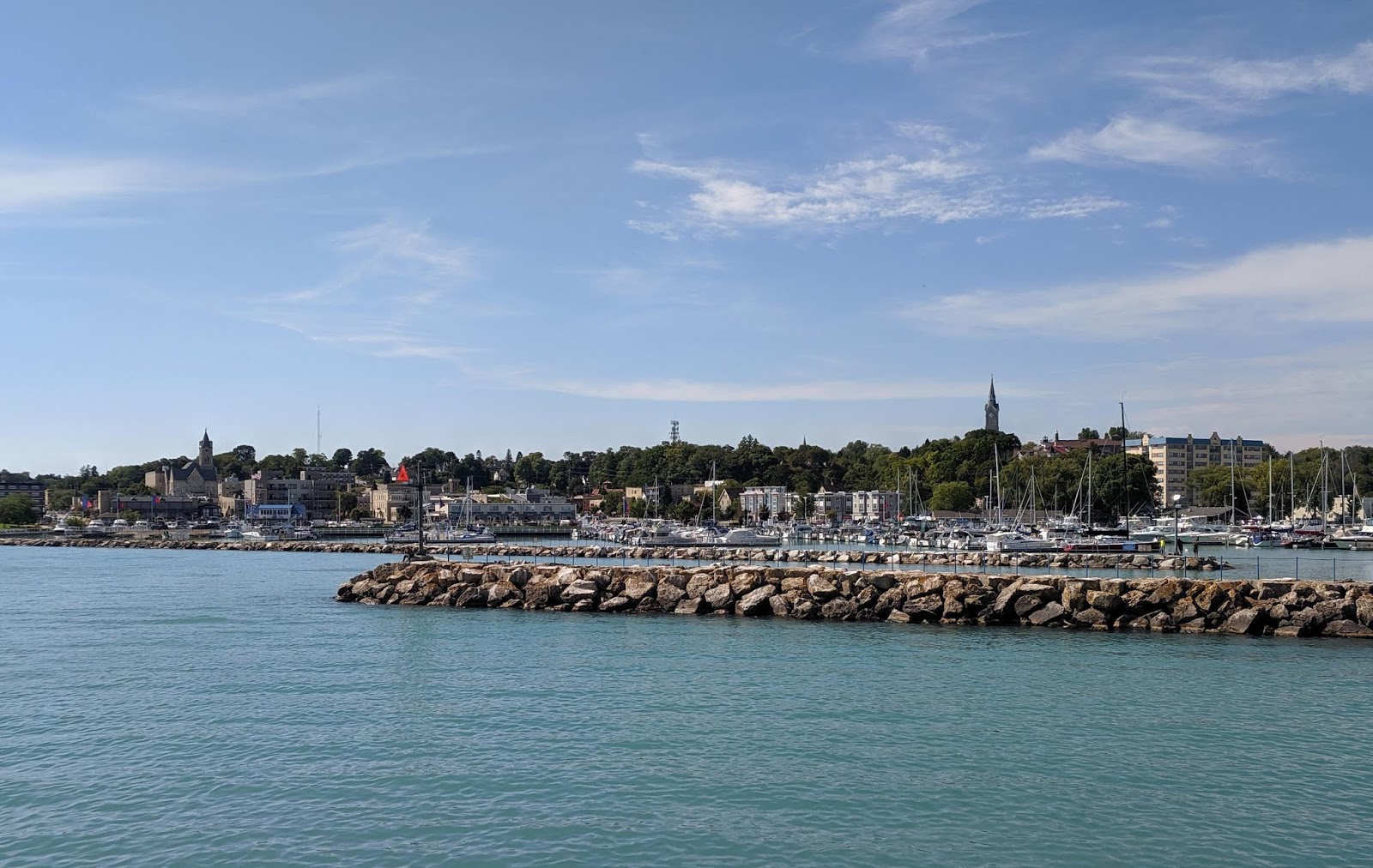
Our early start yesterday paid off, and we were through the Milwaukee Harbor breakwater before 11am, and tied to the fuel dock at McKinley Marina, in the park of that name, by 11. It turned out that we beat the fuel delivery truck by over an hour, with the 68' Sea-Ray just before us cleaning out the last of their old stock. We could not start pumping fuel until 12:30. In the meantime we pumped out our waste tanks, filled the water tank, and had lunch.


Vector at anchor in Milwaukee. Tender is at the Discovery World across the harbor; docks in the foreground are a state park that wanted money.

We had room for maybe 900+ gallons, but their dispensers automatically shut off at just over 405, so we ended up taking on 810 gallons at the best price on the lakes, $2.469 per gallon. Bunkering took a full 90 minutes, and we shoved off for the very short cruise across the harbor to Discovery World Bay, a tiny protected harbor-within-a-harbor adjacent to the interactive child-oriented science museum of the same name. We dropped the hook right in the middle by 2:30 (map).

We splashed the tender and I headed ashore with the e-Bike, tying up at the Discovery World public dock. Signs regarding dock fees had been blanked out; I think they're done for the season. I made a whirlwind tour of Milwaukee, running northalong the harborfront and then west to the river before heading south into the historic Third Ward, around by the river entrance and under the highway bridge, and back along the harborfront past the Henry Maier Festival Park and back to the dock.


Pabst Theater.

It was an interesting, if brief, tour, and I passed a few landmarks including Pere Marquette Park, the historic Pabst Theater, the Milwaukee Public Market, and numerous well-kept historic buildings made of the cream-colored brick that gives the city its nickname. Urban renewal is well along in downtown Milwaukee, which sports a good mix of residential, commercial, and retail. A nice riverwalk is mostly complete along the historic river.


Milwaukee River across from Pere Marquette Park.

We returned ashore to the same dock at dinner time and walked a few blocks north to the University Club, overlooking Juneau Park and the lakefront. We crossed the very busy Lincoln Memorial Drive on the fancy cantilevered suspension pedestrian bridge attached to the equally swoopy and modern Milwaukee Art Museum. It was perfect weather for an evening stroll.


City Hall Clock Tower.

When we returned to Vector we hip-tied the dinghy and left it in the water. The forecast at that time suggested a slight possibility we might be able to stay one more night. But at 7 this morning is was clear that tomorrow would be much rougher than today, and, not wanting to risk it deteriorating further and pinning us in Milwaukee for the better part of a week, we decked the tender and were headed our of our cozy little anchorage by 7:20.


The city is full of well-kept architecture.

We had big three-foot rollers for the first couple of hours, tapering off as we made the turn to a more southerly course just off Racine. We've been on the same heading for 25 miles, with nearly 30 still to go. Seas have been dropping throughout the day and it's a very comfortable ride now. The plotter says anchor down around 6:30, and we'll be glad to have a beer and a nice dinner aboard.

I normally would not post like this two days in a row, but this is our last "at sea" time until we leave Chicago, in about a week. I know from experience that it's hard to make time to blog while we are in port. We have only one more open water passage ahead of us, from Chicago to Calumet, where we start the Illinois Waterway (IWW) portion of the trip.


Public Market in the historic Third Ward.

Speaking of which, three of the IWW locks are scheduled to shut down for maintenance at 6am on September 21st. They will not reopen again until October 5th, or perhaps later if anything goes sideways. Thus much of the "hustle" we've been doing here in Lake Michigan has had the objective of getting us to the other side of those locks before the closure. Of course, if I had been (or still get) deployed for the Red Cross, we'll miss that window and will have to wait until they reopen.

That's not any sort of crisis; everything here in the lakes is still open through mid-October and the weather, while cooler, is still comfortable. And if I get deployed now, at least we'll be in Chicago, where I know the airports are easily (and inexpensively) accessible. Plus, Vector can ride on a relatively inexpensive mooring here that comes with tender service so Louise can come and go as needed.


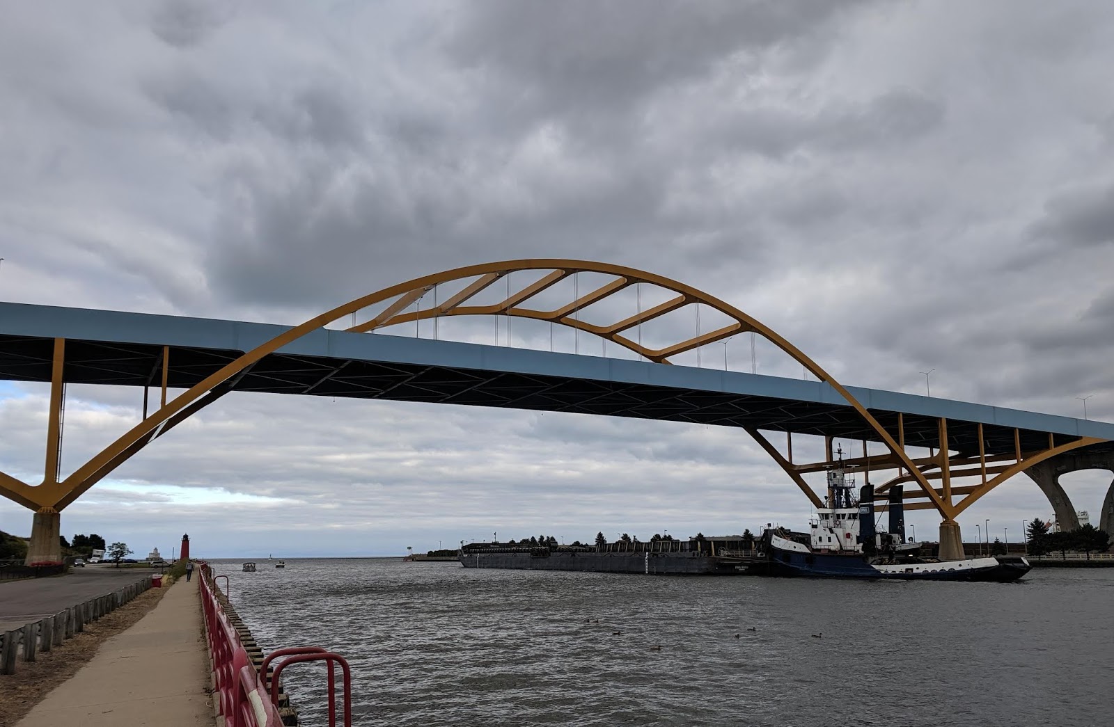
A towboat pushes a large barge under the Hoan Bridge on its way to the lake.

In order to have enough buffer at each of the locks to accommodate waiting several hours (commercial tows, which will be scrambling to get through, have priority) and also to time the infamous low bridge in Lemont at a reasonable pool level, we have set a target of departing Chicago no later than the morning of the 15th. A day or two earlier than that would give us a more comfortable margin of error.

That gives us about a week, knowing that the September lake conditions, as we've seen, can be finicky. We'll be watching the lake forecasts carefully as the time comes, and we'll leave when we have good conditions as far as Hammond, Indiana. My next post here will likely be under way from Chicago in about a week.

Friday, September 6, 2019

Bound for Cream City

We are underway southbound in a very bumpy Lake Michigan, the Milwaukee skyline growing larger in the pilothouse windows. We got an early start due to weather, and the plotter says we'll be inside the harbor breakwaters by 11am. We are already starting to see fall color here along the shoreline.


Manitowoc Breakwater Lighthouse.

Wednesday we rounded the interesting Manitowoc Breakwater Light and had the hook down in Manitowoc Harbor (map) just in time for 5 o'clock beer. Afterward we splashed the tender and headed ashore to have a look around and find some dinner. The city very generously provides free courtesy docks right downtown along the Manitowoc River.


USS Cobia in front of the Wisconsin Maritime Museum.

We enjoyed our very short cruise upriver past the WWII submarine Cobia docked in front of the Maritime museum, as well as our stroll around the historic downtown. We had dinner at the well-rated Courthouse Pub across from its historic namesake. We walked through Burger Boat Company Park, whose namesake is the last remaining shipbuilder in town, on our way back to the tender.


Possibly the largest bollard we've ever used for a tender. Before we found the easier bulkhead with smaller cleats on the other side of the bridge.

Manitowoc was a nice stop, and we could easily have spent another night or two there. But yesterday was one of the best travel days on the lake, with the window rapidly closing, and we decided to make tracks while we could. In fact it was so glass calm on the lake that we blasted right past Sheboygan and all the way to Port Washington Harbor, where we dropped the hook just a bit after 3pm (map). It was a beautiful, warm afternoon, and I splashed the tender and went ashore to have a look around.


Downtown Manitowoc.

There is a quaint downtown right near the harbor, with perhaps a half dozen restaurants and a few shops. The town bills itself as something of a fishing mecca, and in addition to there being maybe a dozen charter boats in the harbor, the jettys on all sides were lined with fishermen the whole time we were there. We returned ashore at dinner time and had an enjoyable meal at the Twisted Willow right on the main drag.


Manitowoc Courthouse. With an ugly afterthought fire escape stuck on front.

A bit of a rainstorm blew threw while we were eating, but all was dry again when we strolled back to the tender. As we rounded the marina jetty into the harbor, however, we encountered significant swell of two feet or so. We could see Vector pitching as we approached, and when we arrived, the swim platform was bashing up and down too violently to disembark. We had to bring it alongside and use the side boarding gate to get back aboard, and we hip-tied it for the night as it was too dangerous to lift.


Port Washington from our anchorage. The marina is separated from the outer harbor with this jetty.

We need fuel. For one thing, we have just 200 gallons left, which will only get us just shy of 400 miles, barely reaching the Mississippi. Perhaps more importantly, we want to be sitting as low in the water as possible when we reach the infamous 19'8" bridge in Lemont, Illinois; another 5,700 pounds of fuel on board will help with that. Port Washington and Milwaukee have been running neck-on-neck for the cheapest fuel on our route, but when I called yesterday they both told me they would be adjusting their price this morning based on new deliveries.

Thus when we awoke this morning, still pitching as much as when we returned from dinner, I called both marinas for an update. Milwaukee has the edge right now, and we'll fuel there, but we still had to head into the Port Washington marina this morning to get out of the swell just long enough to deck the tender. In hindsight we should have realized this harbor was too exposed to SE swell to be an anchorage last night.


The view the other direction, to the harbor entrance. With SE wind the swell came right in. That's our anchor day shape at bottom right.

Today's forecast called for more of the same until mid-morning, when the wind would clock around from south to north through west. In just the time it's taken me to type this post, the wind has become northerly and the seas are much flatter and more comfortable. When we arrive in Milwaukee we'll spend a couple of hours at the fuel dock before heading to an anchorage closer to town.

Wednesday, September 4, 2019

Vector homecoming

We are under way southbound in Lake Michigan, roughly abreast of Kewaunee, Wisconsin and headed for Manitowoc. There were eight footers on this part of the lake yesterday; today it's like a mirror.

Not long after my last post we turned into Sturgeon Bay from Green Bay, and steamed the roughly four miles to the city of the same name, where we dropped the hook in an off-channel corner that used to be billed as a harbor of refuge (map). We got a good set and put out 100' of chain, in anticipation of possible 40-knot winds.

On our way into the harbor we passed the USCGC Mackinaw, WLBB-30, to port. You may recall I toured through her predecessor, USCGC Mackinaw, WAGB-83, in Mackinaw City a few days ago; the old Mackinaw was decommissioned and the new one commissioned on the same day. The older Mackinaw was strictly an icebreaker by design, whereas the newer one was designed for the dual role of icebreaker and buoy tender, and thus looks very different.


Passing USCGC Mackinaw to port. Note the well deck for buoy duties.

We splashed the tender after setting the hook, and I went ashore to explore the town. Cleft in two by the bay, there are actually two small business districts on opposite shores, connected by a pair of bascule bridges. A free city dock with a four-hour limit provided convenient access, and I enjoyed strolling both sections of the quaint downtown. Perhaps a dozen restaurants are an easy walk.

We went back ashore at dinner time and walked over to Door County Fire, a casual joint in a former firehouse that reminded us of a similar establishment in Rochester. We replenished the beer supply at a mini-mart on our way back to the tender. Sadly there is no real grocery store in walking distance. although I could have biked over to a Target if we had needed anything there.

Yesterday we settled in for a long, stormy day. The forecast proved to be an exaggeration; the predicted 40-knot wind never materialized, topping out at just under 30 instead, and the storm had pretty much moved through by early afternoon. Lake Michigan remained a mess all day, as revealed by a number of web cams we looked at.

I knocked out a couple of projects yesterday, including making a new support for our anchor day shape that slips over the burgee staff, and replacing the impeller on the generator. This latter project was unscheduled; we haven't run the generator since mid-August, just before arriving in Detroit, and the impeller self-destructed when Louise started it up. As luck would have it, I was ashore at the hardware store getting parts for the other project at the time.

I've gotten quite good at changing these impellers with a minimum of fuss. The impeller itself is a five-minute project, but when they shred like this the little rubber bits end up in the heat exchanger, and I have to drain a half gallon of coolant, remove the end cap, and clear the debris before putting it all back together and replacing the coolant. That's another five minutes once the unit is cool enough to touch.


I think they misspelled Dork at this sturgeon-head selfie spot.

The rest of my day went down a Facebook sinkhole. As the reports of massive destruction in the Bahamas started to come in, posts started to cross my feed from the half dozen or so boating groups in which I participate, many suggesting people were planning to mount personal relief expeditions in their boats, carrying disaster supplies. If you are a long-time reader, you may know that I have talked about how unhelpful this is in the past, notably here and here.

Those of us in the disaster relief community call what happens when people send unsolicited goods or, worse, show up uninvited to help, the "Second Disaster." You can Google that term to turn up numerous articles about why it's a problem and how relief agencies try to cope with it. Rather than write another diatribe about it here, where few will see it, I instead wrote an impassioned eight-paragraph post about in on Facebook, complete with links to legitimate channels for contributions.

I shared that post in the nearly dozen boating-related groups to which I belong, including a couple for professional captains and yacht crew. Apparently it resonated; in what is as close to a viral post as I have ever come, it was shared hundreds of times and is now well-disseminated in the boating community. Somewhere along the line, it got picked up by Passagemaker Magazine and posted in their online section, complete with a bio that they made up by stalking my profile, and an old photo of me taken, I think, during the Katrina relief operation.

Frankly I am a little miffed that a national magazine with a supposedly professional editorial staff republished my work without the courtesy of asking permission. They also substituted their own section of relief links in place of the one I had originally included, and they incorrectly reported that I had been deployed to Dorian. That being said, I think the message is important enough that I am happy for the additional exposure, and they did, at least, give me a byline. I am trying to get hold of someone to correct the mistakes. You can read the piece here.

[Update: I have since been contacted by Passagemaker editorial staff. They were apologetic about the mistakes and the lack of prior contact. They correctly understood some amount of urgency in getting the message out -- before anyone set sail, so to speak -- and took my permission to share the post on Facebook as implicit permission to republish; an honest mistake. I am grateful for the amount of additional exposure that the underlying message got through their efforts.]

Of course, I am not authorized to speak on behalf of the American Red Cross, and I never do (except on relief operations when directed to do so by Public Affairs). In my original post, I was very careful to say merely that I was a "relief worker" without identifying an agency (not that it's hard to figure out). Since the magazine outed me, so to speak, I had to reach out to Media Relations this morning to give them a heads-up.


Vector at anchor in Sturgeon Bay.

In any event, in addition to the time I spent writing it, I ended up spending a good part of the day responding to and moderating comments on the post. I can only imagine what my friends who manage much larger social media presences go through, dealing with this sort of thing on a daily basis. We went back ashore for dinner at the nice Italian place in town, Trattoria Dal Santo, and a brief stroll.

This morning the forecast said we'd have a good ride to Manitowoc, and we weighed anchor in time for the 8:30 bridge opening. Well, that was the goal, anyway: after ten full minutes of clearing weeds off the ground tackle we conceded defeat. We finally had the anchor up at 8:37, and then tied up to the four-hour dock to await the 9am opening.  The two bascule bridges are just 700' apart, but they open on 15-minute offset schedules, so then we hovered until 9:15 for the next bridge.

There is a third bascule bridge a little further east, but we cleared it without an opening. The bay gets narrower as one travels east, until it eventually ends at the head of the Sturgeon Bay Ship Canal, a man-made cut that connected Sturgeon Bay to Lake Michigan at the end of the nineteenth century. The speed limit in the canal is five knots, but we had a knot and a half against us, so we couldn't do much more than that anyway.

Vector spent the first few years of her life in Sturgeon Bay, where her first owner brought her after she was completed in Nova Scotia. So this was something of a homecoming for her. Between the new top added by her second owner, our friend John, and the different hull color changed by us, plus the dozen years since her departure, there was no indication that anyone recognized her. We're now retracing the path that John took when he brought her home to Savannah.

Today's cruise to Manitowoc is a full eight hours. We could have split it up with a stop in Kewaunee or Algoma, but we've learned to seize the opportunity for progress on these very finicky lakes. We can be pinned down for multiple days at any of these stops, so in addition to putting in more miles, we also prefer to be at a port with more services. Manitowoc has numerous restaurants in walking distance, and a car rental in case I get another deployment call. The same is true of Sheboygan, our next planned stop.

Monday, September 2, 2019

Cheeseheads

We are under way southbound in Green Bay (the bay, not the eponymous city), bound for Sturgeon Bay. We just passed Chambers Island to starboard and the communities of Sister Bay, Eagle Harbor, and Sister Creek to port. I would have started typing three hours ago, when we left port, but I've spent all of that time in a futile goat rope trying to get myself to Atlanta.

Yesterday we were offline most of the day, which, of course, meant that would be the day for the Red Cross to call to deploy me in advance of Hurricane Dorian. My phone was offline all night, too, but Google Voice had helpfully forwarded that message to me in email, which I discovered around 10pm.

This morning thus was a mad scramble, starting with making sure there was a marina in Sturgeon Bay who could fit us and had two weeks of availability -- we had originally planned to just anchor there. Of course, today is Labor Day, and so only one of the five marinas even answered the phone, but, at least they had room, albeit for a price. That gave me the green light to call the Red Cross back and say "yes," and they immediately assigned me to the Georgia operation and started working on travel logistics.


Passing the white cliffs of Washington Island in Green Bay.

That's where things ultimately went off the rails. Even though the Green Bay airport is just an hour away, the cheapest transportation we could find was about $100 each way. The Red Cross has a firm reimbursement limit of $50 round trip, so a $150 disconnect. After a brief discussion here we decided to just eat the difference as an additional donation to the relief effort; after all, just parking the boat for the two weeks I'd be gone was going to be over $1,300. In the end, they decided they couldn't let me pay that much out of pocket (?) and canceled my deployment.

In the meantime, I had used the time offshore on autopilot to completely pack my suitcase, which is still sitting down on the bed. I might just leave it packed; we'll be closer to the airports in a few days, and if Dorian cuts up the coast like a buzz saw as currently projected, there will be more deployments in the coming days.

Yesterday ended up being one our most uncomfortable days on the water since we moved aboard over six years ago. Shortly after I last posted here, we dropped the hook on a shallow sand bank at the edge of St. James Harbor, at the north end of Beaver Island (map). It was dead calm in the harbor, and we dropped the tender to go ashore. We made two trips; one to the private marina for a little (expensive) tender fuel, and groceries from the store next door, and one to the municipal dock in the middle of town.


Vector anchored in St. James Bay, Beaver Island.

We enjoyed strolling the quaint island town before being picked up at the marina by the shuttle for the Beaver Island Lodge, where we had made dinner reservations. Even though it was a spendy white-tablecloth place, it was picture-perfect, with a window table overlooking Garden Island to the north across a small strait. The lodge was otherwise surrounded by evergreen forest. It was all quite lovely.

We had a calm, quiet evening aboard, and I even went on deck late in the evening to look for the aurora, which might have made an unusually southerly appearance (it did not). Our first indication of trouble was a staccato rolling motion when we awoke, which I initially thought was just a bad boat wake. When it didn't stop, we jiggled our way through our first cup of coffee with the weather forecasts open in front of us.

When we had left Mackinaw City, we had a forecast for at least two and maybe three good days on the lake for our crossing; Beaver Island was just a way station. But by yesterday morning the forecast had deteriorated significantly. We were now facing ten hours of 2'+ seas on a short 3-second period. Nothing dangerous -- Vector hardly notices -- but very uncomfortable for the mammals aboard.

Our alternatives were none too appealing, either. We could hunker down in the harbor for several days, moving to deeper water, but clearly the waves were already making their way in, and tomorrow the forecast calls for 8'-9' waves on the lake. We could bash our way east instead of west; a shorter and slightly more comfortable trip, but again we'd be pinned down on the east side of the lake for several days, giving back the westing we had already done.


The small community of Jackson Harbor, Washington Island.

With a possible ten-hour passage, we did not have the leisure of sitting around while we mulled it over. We got under way on our original route, leaving the option to turn back at the edge of the island group if things got untenable. We curled around the northeast tip of the island and steamed through the same strait that we had admired the night before. The lee of the islands provided a comfortable ride until we passed the northwest tip of High Island.

That's when, as expected, things got bumpy. But another hour or so west, the projected 10-15 mph southerlies had already escalated up to the 20s, and the south wind building all morning and running up 250 miles of uninterrupted lake was pushing waves into the four-foot neighborhood. We spent the next six solid hours bashing against four footers with a 5-second period on the port quarter. I increased engine rpm from our normal 1500 to 1700 just to get us through it faster and give the stabilizers a little help. I added another 20 gallons of fuel to the day tank to cover the extra burn.

It was 6pm by the time we finally made the lee of Rock Island, the northermost tip of Wisconsin's Door Peninsula. We passed the Rock Island State Park to port as we made our way into the tiny Jackson Harbor, at the northeast tip of Washington Island, where we dropped anchor in the only part of the harbor deep enough for Vector, right near the entrance (map). The bottom was rocky but we got a set in a light cover of sand.


Turning around Rock Island.

We had leftovers aboard, and Louise crashed hard shortly after dinner. She was already in bed when I discovered the voice message from the Red Cross. Even though it was another potential aurora night, I, too crashed before midnight. This kind of passage is exhausting; it's too rough to want to type, or read for very long, or do much of anything, and just moving around the boat to use the head or get a drink is an acrobatic exercise. Even though it was a day cruise and broad daylight, we each went belowdecks to spend an hour or so in bed, where the motion is the least. On top of all that, it was a very emotional day for us with Dorian visiting death and destruction on the Abacos.

I might have run ashore this morning just to have a look at the small community near the harbor, but with deployment a possibility we instead weighed anchor first thing to get a head start to Sturgeon Bay. Complicating matters was the possibility that Green Bay itself would be too rough in today's northerlies, and we'd have to cross over at "Death's Door", the Porte des Mortes Passage, and come down the lake side instead, adding an hour to the trip.

Other than the mad scramble this morning leading nowhere, it has been a lovely cruise. The Powatomi Islands and the Door Peninsula are stunningly beautiful, and we can look across Green Bay and see the mainland to the west. Had we not been racing to Sturgeon Bay for a deployment possibility, we might well have stopped at one of the small harbors we passed earlier. One thing is for sure: with 8-9 foot seas tomorrow, wherever we stop tonight will be our home for at least two nights.

Saturday, August 27, 2005

Black River Harbor, on Michigan's Upper Peninsula

Yesterday afternoon we traversed the part of Wisconsin that juts out into Lake Superior, after passing through Duluth in the morning. We were on WI-13, after departing US-2. I am sure this peninsula has a name, but I don't know what it is. We ended the day in the lakeside tourist town of Bayfield. We had planned to take the ferry over to Madeline Island, where we read about a nice state park campground, however the ferryman wanted $120 to take Odyssey on a round trip, and we deemed that a bit much for an overnight.

We opted instead to spend the night at the nice lakeside campground, not in any of our directories, run by the city of Bayfield (map). It was beautiful and quiet, though we had some heart-stopping moments bringing Odyssey down the steep park road and under the low trees. The lovely canopy of trees did not diminish our lake view, but did preclude us from getting any satellite coverage.

We unloaded Aquarius and rode back into downtown Bayfield to do the canonical tourist sightseeing and had dinner at Maggie's Cafe. We had thought briefly about boarding the 5:30 Apostle Islands sightseeing cruise, but decided instead to return in the morning with both bikes, and take the ferry over to Madeline for the day, or possibly do one of the island sightseeing cruises.

When we got up this morning, it was pouring rain. Deciding that a day of wet sightseeing and ferry rides on the motorcycles was not really what we wanted, and figuring that the dirt campground road might well turn into impassable mud in short order, we quickly re-loaded Aquarius and beat a hasty exit. While we had been sweating it all night, given that we scraped hard on our way in, Odyssey easily climbed out of the campground with her air bags in the full-up position, and we headed south out of Bayfield. We were thankful for the things we did get to see the previous day, including the Apostle Islands National Lakeshore visitor center, and we will return to visit the islands themselves at a later date.

Today we continued, as far as it was possible, along the southern shore of the lake. Just at the eastern edge of Wisconsin is a turnoff from US-2 that brought us north to the mouth of the Montreal River, with its hydroelectric power plant and a lovely waterfall, Superior Falls. From there we crossed into Michigan along the lake, hoping to camp at the Little Girl Point county park. This park, apparently, remains full all summer, and we ended up returning south to US-2.

Our guidebooks suggested an alternative here at the Black River Harbor area in the Ottawa National Forest (map). It required a 15-mile drive down a dead-end road, but the road is studded with access points to a group of several waterfalls, that we hope to view on our way out. We were rewarded with a lightly-used but well maintained campground, and we were able to grab one of the few "lakefront" sites. It is a perfect spot, and we will probably stay here at least one more night.

A short walk from the campground is a small marina with a handful of sport fishing boats, and a beach accessible by footbridge across the Black River.

We are on a lazy schedule toward Marquette, a few hours east of here, where we will visit some friends Monday evening.

Friday, August 26, 2005

Our wet campsite in Bayfield, WI at the municipal campground. Sean prepares to put the motorcycle away after the rain begins.