
Sunset over Rock Sound, from our deck.
We took advantage of our crossing, wherein we had a few hours well outside the three mile limit, to empty the waste tanks and backflush them well with salt water. We also made another effort to clear whatever is obstructing the forward tank vent, but were unsuccessful; it looks like I will have to disassemble it at some point.
Passing Cape Eleuthera and the marina at Powell Point, we entered the Davis Channel. We had considered the option of docking at the marina or anchoring around the corner just inside the Poison Channel, but it was early in the day with excellent light and calm conditions, so we opted to continue on to this anchorage, which proved to be a wise choice.

Powell Point on Cape Eleuthera. Our channel is at the left of the photo. Yes, it really was this calm on Exuma Sound.
The Davis Channel is really the lone entrance to western Eleuthera from the south, with a broad shoal extending westward from there all the way to the northern Exumas. It can be shallow in spots, but we'd heard it carried at least 9' MLLW all the way through, and our own depth sounder confirmed that. It's good to know that we can easily get through there at any tide level.
After clearing the channel we turned east into the sound, where we finally encountered our first coral field. We'd been given many dire warnings about coral heads in the Bahamas, to the point where we worried that they would litter every cruising route and mandate constant vigilance on the bridge, even to move the boat a short distance. In reality, by sticking to the marked cruising routes in the Abacos and Exumas, we did not have to dodge even a single coral head, and even from the tender we only saw a handful in the whole two months we've been here.
By contrast, on this marked route, which clearly indicates visual piloting is required, we had to drive around perhaps a half dozen coral patches in about four miles. The bottom is white sand in 10-12' of water, and the coral stands out starkly against it; with the sun behind us we could easily see them from the flybridge at least a quarter mile out, giving us plenty of time to gently adjust course with the autopilot. Fortunately there are no corals or other obstructions here in the harbor, where depths are 8-10'.
A gentle breeze was blowing when we dropped the hook, but the harbor was calm. We had thawed some steaks for dinner, but we decided to take advantage of the settled conditions to splash the tender and head ashore. We went to the lovely and upscale Wild Orchid restaurant, which has its own dock, with the advantage of being the closest dock to the bank and grocery store.

Wild Orchid. We were the only patrons.

They had this lovely deck, too, but we thought it would get too sunny.

The bar on the deck.
After a very nice dinner and a couple of beers, we walked the half mile or so to the bank and replenished our cash, with each of us drawing our limit from the ATM. Unlike tourist-heavy Georgetown, where the ATM gives a choice of US or Bahamian dollars, this was strictly Bahamian currency. On the way we passed the nice grocery store, hardware store, and NAPA auto parts, all of which would have to wait until Monday.
As it turned out, our decisions to continue to the harbor and then to head ashore Saturday evening seemed prescient when we awoke Sunday to 20-knot winds out of the west, whipping up the harbor into a frothy mess. Vector hardly moved and we were quite comfortable aboard, but we would have gotten tossed about and drenched trying to go anywhere in the dinghy. A good day to remain aboard and tackle a project.
On our last passage, from Black Point to Halls Pond, a routine engine room check found the stuffing box temperature skyrocketing. We were able to mitigate it by going full astern a few times; this forces more water through the box by backing it up the shaft tube past the cutless bearings. We had hoped it was just some silt reducing the water flow that might work its way out, but halfway across Exuma Sound we found the temperature heading back up again. The rest of our cruise Saturday, including in the midst of the aforementioned coral patches, we'd have to stop periodically and shift into reverse.
So Sunday morning found us in the engine room bilge, repacking the stuffing box. There's nothing quite like opening up a 2.6 square inch hole in the boat (the difference between the shaft and its tube) three feet below the waterline, far away from help, to get one's blood pumping in the morning. Fortunately, almost all of that water went directly into the sump I had installed below the stuffing box, and the little bilge pump in there was able to keep up with the flow without even running full-time.
Adding to the anxiety was the fact that we have only a single ring's worth of new packing, whereas the box takes a minimum of six. So really I could only screw up one ring in the removal or repacking process. We had no need of the spare, as all rings came out intact.

Removing the packing. The tool has a corkscrew end which digs into the Teflon ring, which is dark gray because it is graphite-impregnated.
We were expecting to find the rings caked with mud, silt, or other foreign matter, as we did the last time we went through this exercise. They were, however, surprisingly clean, with just a bit of brown material that we judged to be rust. Sadly, that means the inside of our shaft tube is again rusting, despite hours of careful prep and epoxy painting done at our last haulout.
We cleaned up all the rings with a toothbrush and fresh water, but there just did not seem to be enough material there to account for the overheating. I did find that the box itself was "drooping," with less gap on the top side of the shaft than the bottom. The packing itself was holding the box centered on the shaft, which would account for lots more friction at the interface on the top side. I loosened up all the clamps and did the best I could to re-center the box. Probably what I really need to do is rotate the box 180 degrees to account for the "set" that the hose has taken, but that requires fully removing the clamps and I was unwilling to risk it this far away from parts and help.
It's all back together now, but only an extended run of at least a couple of hours will tell us if things have improved. Also, just removing and replacing the rings and the flange means we will have to adjust the compression several times just to get the flow right, and only then can we get meaningful temperature readings. We hope to have a sense after our next hop.
The wind and the chop persisted all day Sunday, all night, and all through Monday as well, finally calming down around sunset. Thus we did not make it to the stores Monday, either. We were itching to get off the boat, though, so we took the tender to the town dock and had a nice sunset walk into town and around the "Ocean Hole," a brackish lake, some 600' deep, that is connected to the ocean via deep underground passages. We could see quite the collection of reef fish, but the light was too poor to get a photo.

Louise in front of the Ocean Hole, which we walked around. Behind her across the lake you can see the steps leading to the water.
It was perhaps just as well that we were stuck on the boat most of Monday, because I awoke that morning to a dead laptop. The screen was not coming on, neither could I get it to work with external VGA or HDMI displays. I ended up taking all the skins off to try to repair it; I can only surmise a pinched cable or intermittent ZIF connector, because somewhere in all the prodding I got the screen working without really knowing why. I carefully buttoned it all back up, but the project took all morning and then some.

Asus entrails.
One consequence of two days of westerlies followed by calm is that it became hot, still, and humid here since then. We've been running all four air conditioners whenever we run the generator to charge the batteries, about three hours a day in this climate. That cools and dries the boat, and also finally lets us load the generator enough to avoid wet-stacking and clear out some of the gunk. When the A/C is not running, we sometimes jump in the harbor to cool off; the water temperature here is a perfect 87.
Yesterday it rained on and off, but we took advantage of a mid-day gap to run back to Wild Orchid for lunch and a run to the stores. Neither the hardware nor auto parts stores had the charts I wanted or even many marine items -- this is not a cruising town; in fact, there have been fewer than ten boats in the whole harbor since we arrived, and until yesterday we were the only power boat. The grocery was fairly well stocked, though; we had seen the mail boat unloading in the morning and figured they might have some fresher produce than if we had made it there Monday.
We trundled back to the dinghy with all we could carry. Each of us sported a backpack and two hand-carry bags. It's good to finally be well-stocked, even if we paid about double stateside prices. We passed the Kalik distributor as well, but I did not have any hands left to haul a case of beer, so we'll get that elsewhere along the way.

Beast of burden. The left bag is insulated and contains the milk, sausage, and other refrigerated items.

This was definitely not in the bag when I was carrying it...
When evening rolled around we went back to the town dock and walked down to Sammy's Place for dinner. Sammy's serves heaping portions of authentic Bahamian food. I wanted lobster, but they allowed that the only tails they could get were enormous and really suitable only for sharing; Louise graciously agreed to split a lobster tail with me. This was literally the largest lobster tail I have ever seen; they split it lengthwise and we each ended up with perhaps a 12-ounce portion. Louise could not even finish hers, so I had even more than that.
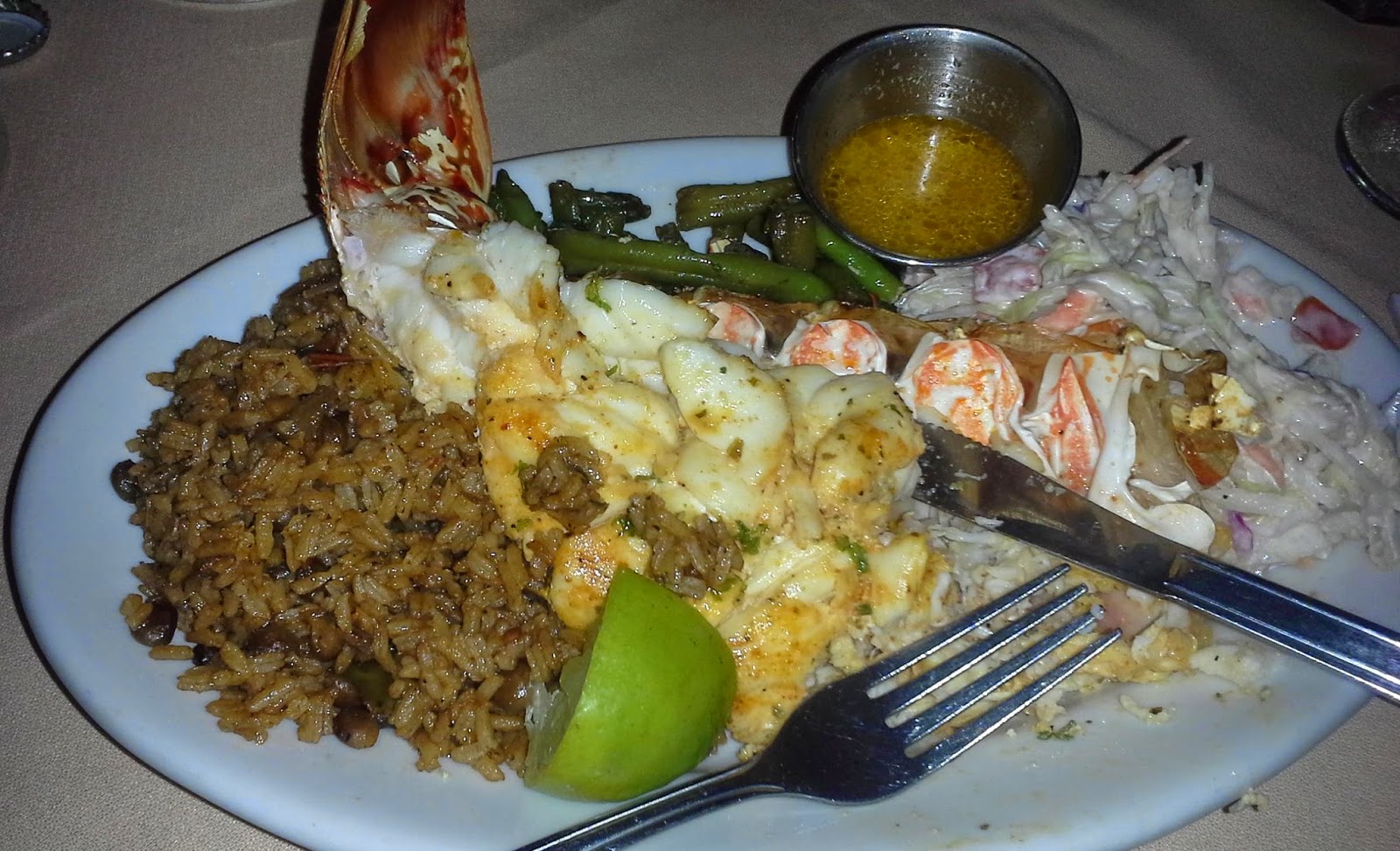
Louise took a photo of her meal partway through. That's half a tail. Traditional peas & rice, slaw, and green beans complete the plate.

Hard to see, but these three rays were swimming near the dock on our way home.
It's been a lovely stay here in Rock Sound, and we got what we came for in the way of cash and provisions. We're ready to move along and explore more of Eleuthera, but at this moment we are pinned down by an approaching thunderstorm. Also the light is not ideal for navigating the corals. If the weather clears a bit this afternoon we might get under way, otherwise we'll be here at least another night.
Our plan from here is to work our way north along the west coast of the island. There are a couple of nice coves along the way and the other large settlement on the island, Governor's Harbour. We may or may not go as far north as Spanish Wells before continuing west across the bank to New Providence. Blossom is there now, at Palm Cay, and we hope to catch up with them before we part ways for the season on our way to Bimini.
We are scheduled to be in Bimini on May 20th, when our good friends Mark and Mary will arrive there on the high-speed ferry from Miami. Schedules being a very dangerous thing on a boat, we are planning a conservative arrival in that neighborhood, anchoring somewhere nearby for one to three nights depending on weather. It's a three-day run there from New Providence once a window opens to cross the Tongue of the Ocean; with whatever time is left over we will cruise Andros or the Berrys.
We are soon to make the trip from Spanish Wells thru Current Cut on to Hatchet Bay. Then further south to pick up Davis Channel heading southwest and then into the Marina at Powell Point. We are on a 70 foot power vessel that draws 5 feet. Was there any issue on depth going thru what is called the Davis Channel. Were there any channel markers or just line of sight. Thanks
ReplyDeleteWe had no issues with the Davis Channel -- we draw 6'. Our sounder found no less than 9' MLLW the whole way. There are no channel markers, per se; a concrete obelisk marks a shoal and serves as a landmark. We steered a GPS route to one of the Navionics magenta line courses.
DeleteSean,
DeleteThank you for your comments. Could you guess at the width of the Davis Channel. Also did you enter Hatchet Bay by chance and if so describe width of channel opening and mooring balls if used. Finally did you enter Current Cut from the Southeast. Looking at a Nobletec chart magenta line brings you in at 309M heading Northwest.
It appears that right at the entrance there is shoaling that would immediately be to both port and starboard and is showing 3feet to starb and 4feet to port. I am curious how wide this initial part of current cut channel is as we are 25beam and need 5min. I guess if we approach high slack tide we can float over. Any of your comments appreciated
Thanks
William
Davis channel is quite wide; it's a natural feature not a dredge. We did not go into Hatchet Bay as it looked unappealing to us. Also we did not use the Current Cut. I'm not sure what chart you have, but IIRC, you make a hard turn to starboard after the cut, if you are southbound, for the deepest water. The Explorer chart shows it correctly. If you follow that route there should be plenty of water, but, as I said, we did not come that way.
Delete