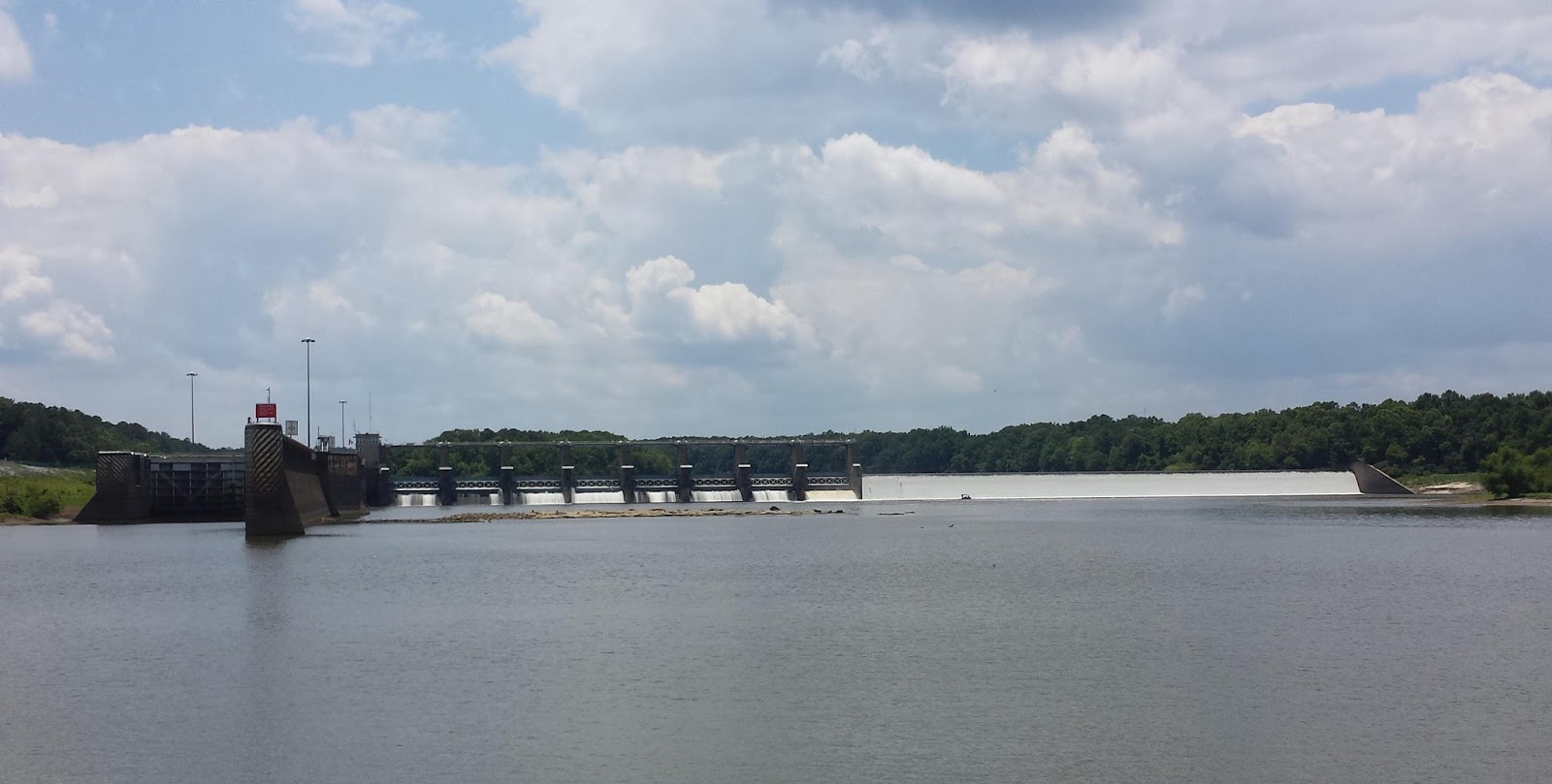
Coffeeville Dam, our first lift of the trip, with water barely cresting.
And so I find myself once again behind on the blog, with nearly a week's worth of updates in one post. In that time we've covered some 220 statute miles of the Black Warrior Tombigbee Waterway and transited two locks; we're now about 74' above sea level.
We had a very long travel day after leaving Big Bayou Canot on Tuesday, covering 69 statute miles. There are not a lot of anchorages north of Mobile (and no marinas until Demopolis), and fewer still are open to Vector at low water levels. When we left the bayou the tailwater at Coffeeville Dam was 4.5', and by the following morning that had dropped to just over three feet.

The W K Wilson I-65 bridge.
Shortly after leaving the bayou we crossed the rail line at the 14-mile bridge; here close to sea level the bridge had to open for our passage. Next up were the twin spans of the General W. K. Wilson Bridge, which carries I-65 over the Mobile River. This bridge is colloquially known as the Dolly Parton bridge for reasons that... umm, I'll just post a picture.

Sometimes referred to as the Dolly Parton Bridge...
At mile marker 45 we left the Mobile River behind; this is where the Tombigbee and Alabama rivers join to form the Mobile. The Alabama is navigable all the way to Montgomery, and it would be a lovely side trip, but we simply do not have the time to do them all in one season, so we continued on to the Tombigbee. A few miles later we came to our first planned stop, the Alabama River Cutoff, which connects the two rivers again further upstream, but without the barge traffic.
We had gotten an early start, so it was still early afternoon when we arrived. Rather than drop the hook this early in the day, only to have to run the generator most of the afternoon to keep cool in the brutal heat and humidity, we opted to continue on to the next anchorage at Old Sunflower Bend (map), letting the big alternator run Mr. Roboto in the pilothouse all afternoon instead. That had us stopping much closer to dinner time and kept a few hours off the genny, a theme that would repeat itself over the next few days.

In the Coffeeville Lock just before the fill. The miter sill is clearly visible.
While the downside of low water levels is the scarcity of deeper anchorages, the upside is lower current. I had planned for over a knot against us on the river, and we've had less than half that in the freshwater and even less in the tidal portion of the river. That's a good tradeoff for us.

Vector is tied off with just a single line to a bollard on a float, which rises with the water level.
Wednesday's cruise put us at Coffeeville Lock and Dam mid-afternoon. With water in the lake just over the crest of the dam, we had a lift of about 34'. We then cruised right past our originally planned stop for the day, a rickety dock at a place called Bobby's Fish Camp. Vector has been here before, and we might have enjoyed checking the place out under different circumstances. But as their restaurant is not open Wednesday it was definitely not worth 80 bucks just to tie up for the night and save perhaps five hours of generator time.

Lake level, 34 feet up, and the gates are opening.

The rough concrete wall is unforgiving. The ladder to the left is recessed in the track for the floating bollard.

We're using our, um, big balls to keep us off the walls, and they are taking a beating. That's mud from the concrete on the bottom.
We ended up dropping the hook a bit further upstream at a wide spot in the river known as Turkey Point (map). There's a sandbar here that let us anchor without risk of swinging into the barge channel, and as a bonus, that put us close enough to shore for me to swim over to the beach. It was an unexpectedly pleasant stop. Also unexpected was the weird eddy current here that had us pointed downstream for most of our stay.

Vector anchored just off the beach, to which I swam to get this shot.
Anchorages on this stretch of the river are even scarcer than on the tidal portion. Many of the anchorages listed in our guide seemed not to exist at all, with some appearing to be in the marsh. That started to make more sense during Thursday's cruise when the several bridges we passed under all had a good 20' of clearance above what was shown on our chart. The banks are littered with down timber and other evidence of raging spring floodwaters, now well behind us.

Demopolis Dam.

Demopolis is a taller lock; note the higher sill.

Now at 73' above sea level...
Friday brought us to our second lock, at Demopolis, which lifted us some 40'. Shortly after exiting the lock we passed the Corps of Engineers campground at Foscue Creek, where we stayed in Odyssey on our first visit here. Naturally I had to take the complementary picture looking right back at our campsite.

Foscue Creek Campground now...

...and then.

This guy seemed content to ride the bollard up in the shade...
In addition to the two-hour shopping spree, which included ten gallons of motor oil, a case of beer, and other heavy items that are hard to move without a car, we spent most of the day yesterday working on travel plans. We've had it on our calendar for some time to set up a trip mid-July to California, where we both have many long-time friends from our two decades living there, plus a rental property to check in on. We also need to meet with our financial planners there, and Louise has family in the area. She's been back once since we last left there in Odyssey in 2012, but this will be my first return visit in over three years.

Water cascading over Demopolis Dam.
Nailing down exactly when we'd do this and where we'd be when we started has been something of a moving target, since we were not entirely sure when we'd start up the Tombigbee or what kind of daily progress we would make. This week has been the first time we've had enough information and confidence to put a stake in the ground.
Looking at a map of the navigable river system in this part of the country, it becomes readily apparent just how few real cities there are along the way. And by real city, I mean one that has an airport served by commercial flights. In point of fact, after leaving Mobile, the very next city along the main part of the route is Paducah, Kentucky, a distance of 670 miles, or a little over two weeks at our normal pace.
If we went straight to Paducah we'd already be on the downhill side of our trip, missing some interesting side trips. While we've already opted not to take the Alabama to Montgomery or the Black Warrior, which split off back in Demopolis, to Tuscaloosa, we definitely want to make the 500-mile round trip to Chattanooga from where we join the Tennessee at Pickwick Lake. Chattanooga, of course, has an airport, as does Huntsville, Alabama just a couple of days downstream.
And so it is that we've booked a round-trip flight out of Huntsville on July 13th for a one-week trip to San Francisco. We're still finalizing marina arrangements for Vector in nearby Decatur or maybe Scottsboro, as well as a kennel for Angel. Managing all the variables from ground transportation to marina fees to flight times means it's never a slam-dunk to make flight plans in a nomadic lifestyle, particularly when we are both traveling and neither of us remains behind to watch the boat and the cat.
The outbound flights now dictate our pace; it's a comfortable schedule, even if we have a bit more current against us in the Tennessee. We'll be in quarters a couple of days ahead of time to get the boat and the cat squared away, and when we return we will continue upriver to Chattanooga before turning around.

Vector at Kingfisher Marina in Demopolis.
Now with a clear but relaxed schedule, and enjoying both air conditioning and good WiFi, we decided to make it a short day yesterday and ask the marina for a late checkout. In addition to making more progress on travel plans, we filled the water tank, pumped out the holding tank, and I took the aforementioned dip in the pool. We finally dropped lines at 2:30pm, 23 hours after our arrival, to come here, just eight miles upriver.
It's so hot now that we had to keep the boat closed up and the air conditioners running all evening and right to bed time. It was all I could do to stand on the deck to grill a couple of pork chops. The cat, who loves the heat, asked to go out on deck sometime after sunset, and I let her out.
When I went to let her in some time later, all hell broke loose. Somehow we stumbled into a mayfly hatch (or perhaps our lights had something to do with precipitating it). They were attracted to our lights and there were thousands of them on the aft deck; a couple dozen made it inside in the brief moment the door was open. The cat seemed shell-shocked.

Just some of the mayflys on deck this morning.
This morning the aft deck was covered in mostly dead mayflys. The dinghy was worse; the permanent solar-powered running/anchor light we keep on it also attracted thousands, and there was a mat of dead mayflys three inches deep across the back of the dinghy. I spent an hour this morning blowing as many of them as I could off the deck with a compressed air hose and a shop-vac running in reverse. We'll be cleaning mayfly carcasses off the boat for weeks.

A small percentage of the mayflys in the dinghy.
Today's cruise will take us all the way to the tailwater of the next lock, the Howell Heflin Lock and Dam, where we'll anchor in a nearby oxbow for a lock-through in the morning. I don't have enough cell signal here to load the photos, so I'll post this just as soon as we pass through a spot with enough 3g or 4g coverage to get the job done. I have no clue whether we'll have any signal tonight or not.
Too bad you you missed Bobby's Fish Camp. It's more of a rite of passage that a marina.
ReplyDeleteWith the restaurant closed it made no sense at all. And, honestly, we don't need those rites of passage that cost eighty bucks a night for what amounts to a rickety dock with no services. If we needed provisions in Coffeeville we might have considered it.
DeleteBesides, we've stayed at Jimbo's, back in the day, and it's hard to imagine Bobby's, or any other fish camp, being any more a rite of passage. And at least from Jimbo's you could walk to one of the pretties and most deserted beaches in all Miami/Dade...
*prettiest
DeleteSean, Not sure if you have been to Joe Wheeler State Park but it makes a good stop for Huntsville Airport, if you can find a ride. I keep our houseboat there and it is very protected. If you are there on the weekend be glad to loan you a car for shopping or dining. Slip 723. Enjoy reading your blog.
ReplyDeleteWe've been to Joe Wheeler in our RV, actually. And we'll stop in the boat, too, perhaps on our way back downriver. It's not a good choice for the airport because it's $0.50 more per night than the place in Decatur and it's a much longer Uber ride. Thanks for the offer, and if we are there on a weekend we may look you up.
Delete