We are under way westbound across Oneida Lake, which is flat calm as I type, headed for Brewerton. Or, more correctly, Central Square, just across the canal. The plotter is showing a noon arrival, which is uncharacteristically early for us on this trip, but we have packages waiting there in an Amazon locker, and we can use a little break. I don't expect to finish this under way, so it will likely be posted this evening.
 |
| Fourth of July sunset over Coxsackie and our ensign. |
We ended our day Monday off Little Nutten Hook (map), across the river from Coxsackie, a familiar anchorage and further than we had planned. The river in that area was incredibly busy for the holiday, with lots of small boats and PWCs zipping around, and people out on the sandbars. We had the hook down just before dinner time. We neither saw nor heard any official fireworks displays there, but there were a handful set off privately on the Coxsackie side. After that it was a quiet night.
The extra mileage on the holiday meant we were able to finish on the Hudson and make it all the way to Waterford on Tuesday. We dropped a lunch hook just before the Amtrak bridge in Albany (map) to lower the mast, which needed to be down by the Troy lock anyway, so we did not have to have the bridge open. Troy has reopened their marina since our last visit, so it's unclear whether the free wall we've used in the past is still permissible.
 |
| A beautiful woman and some scruffy unshaven guy in front of the mule in Waterford, during a gap in the rain. |
We were locking up at the Troy Federal Lock by 2pm, and tied up at the free wall in Waterford by 2:30. While there was still one spot on the face dock with power, we had no need and instead tied up to the concrete wall (map) as we did on our first visit. It rained on and off our entire stay, but we got a bit of a walk in during a lull in the evening.
Wednesday morning we cast off and headed up through the "Waterford Flight," a group of five locks in quick succession. We did two more, locking up through E-7 and E-8 before ending our day at the upper guide wall of lock 8 (map). We were tied up by 3pm, stopping early principally because there is a power pedestal at this lock wall. I did have to rummage through my big box of adapters and cobble together one to make use of the "range" or "RV" style 50-amp outlet.
 |
| Quickly made adapter. Between the range plug and the marine receptacle can be seen the shell from yet a different plug I removed for the task. |
Our first time through here, we stopped at all the interesting towns along the way, doing the canal at "mule pace," or around 15 miles a day, just like you remember from the song. It was very enjoyable that way, but this time we are pressing forward into the lakes, having made a late start from the Hudson. We spent enough time at all the stops back then that we do not feel like we are missing anything to be passing them by now.
Likewise I've not felt compelled to document all the locks and other sights along the route in photos, since they'd basically be redundant for the ones I've already posted. You can follow along on that first transit and see the photos by starting at this post, and clicking "newer post" at the bottom until you get to Lake Ontario.
 |
| The old lock chambers of the Waterford Flight as seen from the footbridge. |
The impetus to make good time to the lakes is to have the best chance at continuing along the Down East Circle, through Quebec and down the St. Lawrence to the maritimes. We were almost to Waterford before it occurred to us to check our insurance policy to see if we were covered, and as it turns out, we were not. We are only covered west of Quebec City, and south of Eastport, Maine. We contacted our carrier to find out about a trip endorsement for the missing piece.
It's going to cost north of a boat unit to insure this leg of the trip. And while we requested a full three months to close the loop from Quebec to Eastport, they will give us just 79 days. Our endorsement will expire October 11 (about as late as we'd want to be in Maine anyway), with coverage in Quebec City starting July 24. That's a somewhat aggressive schedule in a 6.5-kt boat, so now I need to buy the Canadian charts and actually plot the full route to see if it still makes sense.
 |
| A refresher on what it looks like inside the lock chambers. |
In any event, it can't happen at all unless we make continuous progress toward the Thousand Islands. If we end up deciding against it, we'll still have a lovely cruise in the lake, and we will return this way to New York City on a more leisurely schedule.
In preparation for the possibility of clearing into Canada (whether or not we do the Seaway), we've been powering through the food in the freezer and fridge. It all needs to be declared, and it's hit and miss what they will ask us to surrender. We're trying to arrive with no meat, eggs, or fresh produce, and as little alcohol as possible. Our last clearance we made it in with a metric ton of booze as "ship's stores," but again we don't want to count on this.
 |
| There were long stretches where we had the river to ourselves, rewarded with this glassy mirror ahead of us. |
As we continued locking up westward on Thursday, we realized the upper guide walls of the locks were getting lower and lower to the water surface, and a quick check revealed that several pools were running a good two feet above normal pool, and one was right at high pool. There are several bridges on the canal that we can't clear at high pool, and we started to wonder if we would get stuck someplace waiting for water to recede.
 |
| Perched on the flybridge, I get the sunlight and fresh air and the sweeping view of the dam while Louise is still trapped in the dungeon that is the lock chamber. |
We had hoped to spend Thursday night on the upper guide wall of Lock 15, near Fort Plain, where I had planned to make a quick grocery run on the e-bike. When we arrived at the lock, however, the lockmaster informed us that he had a late-arriving commercial tow coming in and they would be on the wall overnight. That meant we'd also be ill-advised to continue to the lower guide wall of lock 16, since we'd just have to move at zero-dark-thirty to let the same tow pass.
 |
| Vector secure for the night at Lock E-8, adjacent some Canal Corporation work boats. |
Instead we continued just past the lock to a wide spot off-channel just before Abeel Island, where we dropped the hook (map). Of course, the anchor light is atop the mast, which is now lowered, and so I spent the next half hour jury-rigging an anchor light from an old pole light, wire, and a lighter plug for the night. Heretofore we've never had to anchor on the canal route, which has a surfeit of free docks. Our odometer rolled past 40,000 nautical miles just before we reached the anchorage, and I reset it to zero a few miles short to make up for some miles we missed in the Harlem River.
 |
| Makeshift anchor light using the pole light from our old dinghy. I zip-tied it to the holder for the anemometer, which was removed for the transit. |
We had chosen to come into Lock 15 on the south wall, to talk to the lockmaster about the tow. That put us right in the turbulence from the fill, and at one point we found ourselves being pushed hard away from the wall. Usually no problem as I compensate with maneuvering, but this time the poorly-attached line we were using as a breast came completely untied from the ring to which it was secured, snapping back and narrowly missing hitting Louise in the face. She was saved by the fashion plate, behind which she was standing while tending the line. We ended up on the other side of the lock, where we grabbed another line.
 |
| Lines at lock 15 are poorly tied, as you can see by the one at bottom, which we grabbed after blowing across the lock. Line on the quay, where we dropped it, is the one that snapped back. |
Yesterday, as we continued to climb to the top of the hill some 420' above sea level, the pool levels came back to normal and even a little low, which made for a different problem as we plowed through the mud in a few sections yesterday. But not before we arrived at the lowest (at high pool) bridge on the whole route, a railroad bridge just below lock 19, which we passed at just far enough below high pool to set the camera on the soft top. In the video below the camera is resting on the aft end of the soft top; there is about 6-8 inches of clearance to the bridge.
Vector passing under the CSX bridge, as seen from atop the highest point.
We spent the night on the upper guide wall past lock 19 (map), where the pool was actually a few inches low. Not long after we tied up, a 76' Lazzara locked through that was an inch or two taller than Vector; the skipper allowed as he had hit his horns on the bridge in the other direction. Since we missed the grocery stop in Fort Plain, I took the e-bike across the canal and rode the three miles east to Schuyler, actually now part of Utica, where there was a mini-mart and a farm stand. Between the two I was able to pick up milk for the morning and some fresh lettuce for a salad along with a couple of other items. I crossed the canal on the very same rail bridge we had squeezed under, since the lock gate walkways were a bit narrow for the bike.
A dredge had been working west of 19 when we stopped for the night, but on a Saturday morning they were shut down. It's sorely needed, as this is the shallowest spot on the whole canal, and we plowed the mud for a hundred feet or so passing the area. We had several other brushes with the bottom through Utica until we reached Lock 20, which brought us up to the top of the hill. The pool is normally at 420', but this time we found it just under 419', the high point of this trip, so to speak.
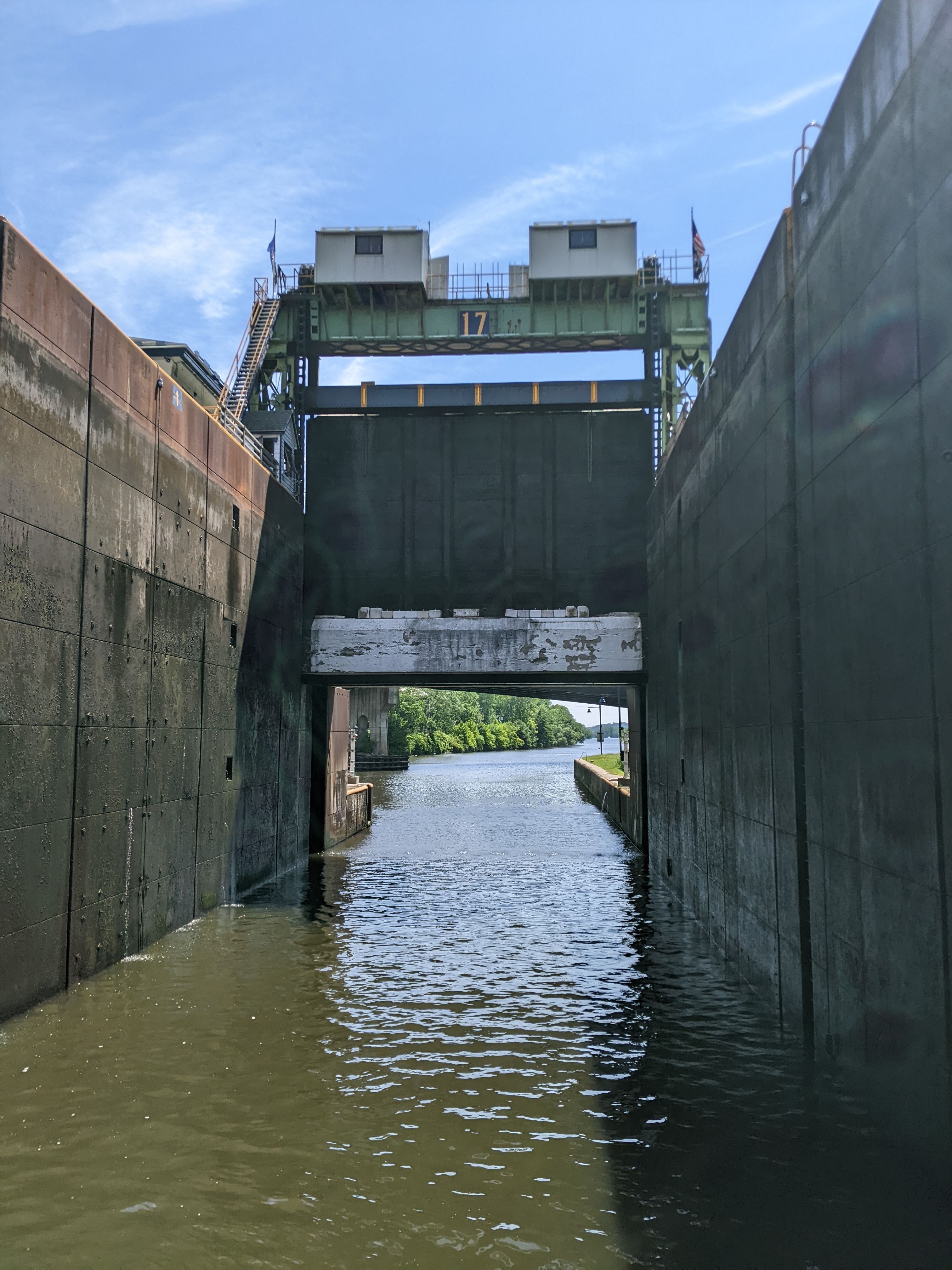
 |
| Inside the tallest lock in the system, E-17, which is leaking more than I remembered. |
Locks 21 and 22 brought us down to today's level, and last night we tied up at the wall in Verona Beach (map), across the canal from Sylvan Beach, and just a few feet from where we docked three years ago. Once again we had wanted to be on the north side, east of the bridge for a quieter experience, but just as then, we arrived on a Saturday, when Sylvan Beach is an absolute zoo. We counted ourselves lucky to find enough space on the south wall for the night. The joint two blocks south that had prime rib on Saturdays has gone out of business; we again ate aboard.
The noise from the amusement park and day boats died down by 10:30, along with the incessant wakes and even the wind that was stirring the lake up. This morning we got under way right after coffee, to beat the crowd and have a calmer lake. I expect things to get very busy as we exit the lake into the Brewerton area.
 |
| The view astern of the guillotine gate at E-17, the only such gate on the canal. |
Update: We are tied to the free dock in Central Square, across the canal from Brewerton (map). We were secured alongside by noon, and I spent a dozen minutes on the aft deck with the shop vac sucking up midges, who had swarmed the boat somewhere on the lake. What a mess. We walked over to the Amazon locker and picked up our packages.
One of those was a shiny new 10" Android tablet to replace the secondary chart computer that sits on the pilothouse table for use by the off watch. We've been needing to replace that computer for a while now, but the urgency has increased since there is no good way to get Canadian charts for it. The new tablet will use our existing Navionics and Aquamap subscriptions, where Canadian charts are an inexpensive add-on. It will also mean one fewer nav programs in the pilothouse, as these two apps are already in use on a tablet at the helm.
 |
| Vector at lock E-19 for the night. |
As I predicted, it's a zoo here just as it was in Sylvan Beach yesterday, and rather than dodge and weave the traffic to get the fuel and pumpout we need a bit further west, we're just settled in here for the night, giving me a chance to finish the blog post and do some more route and border-crossing planning. In the morning we will continue west through one more lock to Three Rivers Junction, where we will turn onto the Oswego Canal headed for Lake Ontario.
Whoa! Most epic blog post ever!
ReplyDeleteEnjoying the blog very much as always. My wife and I did the entire Erie Canal in a low, 35' Albin Command Bridge single-diesel cruiser years ago. We had a few low-bridge scares and hairy locking episodes -- I can't imagine how you muscle your much taller, bigger boat through some of the tricky sections of the Canal. Hope you do the long trip down the St. Lawrence -- read several books about it -- not easy at all, some very tiny ports, few anchorages, quite remote, but beautiful.
ReplyDeleteYes, we are studying other trip reports intently as the go/no-go decision point approaches. The boat will do fine; it's the crew we're worried about ;)
Delete