As we expected, our passage got a bit bumpy after last I posted here. By the time we made the turn into the Beaufort channel, we had four to five footers on a short five second period, thankfully mostly behind us. The turn put them on the port quarter, just as I had to dos-si-dos with a dredge working the green side. I had to hand steer from where we entered the channel all the way to just inside the Bogue Banks.

Sunrise this morning over Pamlico Sound, with Cedar Island receding behind us.
The last half of the passage wiped us out, and we dropped the hook at the first opportunity, a familiar anchorage off the Fort Macon Coast Guard Station (map), just before beer o'clock. By this time, winds were 25kt steady and gusting 35kt. We got a good set, put out plenty of chain, and had a quiet dinner on board. In better times, we would have gone just a bit further to the Beaufort or Morehead City anchorage and tendered ashore for dinner.
We awoke Wednesday morning to just as much wind, with no relief in the forecast for at least another full day. While this anchorage is great as an easy place to stop after a long passage, or a good place to stage for an early morning departure, it's not a good place to sit for a couple of days. For one, it's right next to the channel, and all manner of fast boats come by on full plane, as well as an occasional ship or tug. For another, there is quite a bit of fetch and it can get choppy, along with a bit of swell wrapping around the point though the inlet.

Even in 40 knots, the inexpensive carabiner we are using for a chain hook has been doing fine. These are identical items; the one on the right has been in service for a little over three months.
We briefly contemplated moving to one of the aforementioned anchorages, but with little incentive to go ashore other than to walk, we opted instead to keep moving. The current rips through here, so we waited until 2pm for the flood to start before we weighed anchor and continued up Core Creek, which carries the ICW through here. Core Creek wends its way through a tidal flat north of the bridge, infamous for shoaling. We listened all morning to TowboatUS working an East Bay that had run aground.
So, of course, just as I got to the trickiest, skinniest section, where the deep water suddenly shifts from one side of the channel to the other, I had to deal with a fishing trawler coming the other way. I was on the "wrong" side of the channel, and I tried unsuccessfully to raise him on the radio to make arrangements. In the end I just held course and reduced speed; at the last instant he figured it out and went around me before I had to sound the whistle.

The CoE depth survey overlaid on the chart. We'd be aground in the red areas. I had to run up the left side and then cross over to the right.
We knew the Neuse River would be a mess in 25kt southwesterlies, and so we figured on a short 15-mile day, ending at an anchorage before the river. The Core Creek Canal ends in Adams Creek, where we have a few options. Our usual spot was unusable, on an east/west section of the creek that was sporting two footers as we passed. Instead we continued around the corner to a north/south stretch and tucked in on the west side (map), where we had a comfortable evening and night.
Winds had abated somewhat yesterday morning, and we shot out into the Neuse first thing and made our way to Pamlico Sound. We knew the southwesterlies would be building all day and into the night, and with few protected anchorages, we decided to make a right at the Neuse River beacon and head south, to the lee of Cedar Island. We got slammed with beam seas as we crossed the mouth of West Bay, but once in the lee of the Point of Grass, things started settling down. By the time we got to the neighborhood of the Cedar Island ferry landing, we were able to tuck in about a quarter mile from shore (map) and have a fairly comfortable stop.

View from our anchorage of the Cedar Island Resort, with the Ocracoke Ferry at left.
It was a bit of a challenge splashing the tender in 20 knots of wind, but we really wanted to get off the boat. We headed ashore at dinner time, landing at the boat ramp adjacent to the ferry terminal, and walked to Sharky's, the lone establishment in "town." We were going to just get takeout and eat at one of the picnic tables at the ferry landing, but we found a nice upwind picnic table on their patio and so we ate "in," by which I mean I ordered at the bar and a waitress brought it out to us. We each had a sandwich and a beer; nowadays this counts as fine dining for us.
There's really nothing here except the ferry terminal, a small visitor center, a tiny motel, a barren RV campground, and Sharky's. The place calls itself the Cedar Island Resort. A few houses line the beach north of the landing. South and west is all part of the National Wildlife Refuge. We'd been through here on Odyssey, but we did not even stop after disembarking the ferry. We walked around the compound briefly before returning to Vector, where we decked the tender immediately in the hopes of getting under way this morning.
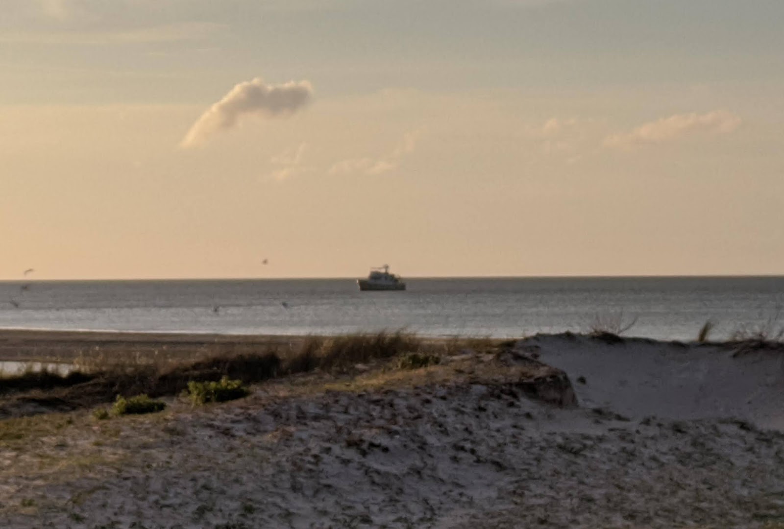
Vector anchored off Cedar Island. View over the dunes from the ferry terminal.
That was looking pretty doubtful at bedtime last night, with seas three feet on three seconds forecast for the northern part of the sound this afternoon. The shallow sound is just miserable in any kind of sustained wind. Still, we made ready for a pre-dawn departure, just in case.
Louise was up early to check the forecast, which had improved overnight. It was dead calm when she rousted me at 0500. With no protected anchorages anywhere along the sound (aside from a long detour to Ocracoke), we knew we would have a full ten hour run, and with seas still forecast to build in the afternoon, we wanted to be through the majority of it as early as possible.

Last night's sunset.
As I wrap up typing, just off Gull Shoal, the plotter is predicting a 3:30 arrival, which should be ahead of the worst of it, and we're still just in one footers. Winds are 15 knots. We'll be in Croatan Sound tonight, and we'll see if we have weather for crossing the Albemarle tomorrow.
This comment has been removed by a blog administrator.
ReplyDelete